
A Garden State Delight
When people in the West find out that Matt grew up in New Jersey, their typical comment is “What exit?” The general image of the “Garden State” is one of dense population, traffic, refineries, pollution, and more traffic. Indeed, New Jersey has the highest density of population in the US, with an average of 1,030 people per sq. mile, which is 13 times more than the national average. (As a contrast, Montana has about 6 people per sq. mile) It is the only state in the nation in which every single county is classified as “metropolitan areas.” She also holds the honor of having the densest system of highways and railroads in the country.
And even though Matt was born and raised there, he knew virtually nothing about the area of the state that the route would take us. “Heck, we never went to that part of Jersey”, he would say. “Why would you?” So you can imagine how surprised we were to discover that we found some of the most rural and idyllic areas to bicycle in that we had yet to encounter. If you learn nothing else from this blog, know this...New Jersey is the hidden gem along this route. The route basically follows the Delaware River from the New York border to Lambertville, approximately 120 miles. We found ourselves on tree lined rural roads that we literally had all to ourselves. There was one section in which we rode nearly 10 miles on a county highway without seeing a car, building or human being. This definitely was not the New Jersey depicted in the media.
 The route took us through the Delaware Water Gap National Recreation area, mainly on the Old Mine Road, so named because in American colonial times Dutch settlers carried copper ore from rich mines located in the area. Houses along the road became vital refuges and forts for settlers during the French and Indian War. George Washington's soldiers used the road and John Adams and Ben Franklin were frequent travelers. During the mid 19th Century part of the Old Mine Road became links in the Underground Railroad. In fact there are 90 sites in the DWGNRA that are on or eligible for the National Register being stabilized and restored for a wide variety of uses.
All of this was slated to be underwater. The National Recreation Area was originally conceived as an adjunct to "management" of the Delaware River. In 1960 the Army Corps of Engineers set upon a mission to build a dam at Tocks Island, just north of the Water Gap. This dam would control water levels for hydroelectric power generation and create a 37 mile lake for use as a reservoir. A smaller surrounding recreation area, to make a more "cost effective" dam, would be administered by the National Park Service.
Tens of millions of dollars were appropriated and work began to prepare the area for flooding. Three to five thousand dwellings were demolished. Some fifteen thousand people were displaced, many of whom represented 300 years and 13 generations of history and culture in the Upper Delaware Valley. A serene region of farms, hamlets and villages along a free flowing river was systematically dismantled as part of a plan that was eventually shelved. There was passionate opposition from many corners to the government's agenda. Some of the more visible historical homes were temporarily spared only to be destroyed by squatters and arsonists. For 18 years the valley was the site of a bizarre free-for-all with an unpredictable outcome.
Finally, in 1978 the project was deemed economically & environmentally unsound, and the government, instead of selling back the remaining 83 homes to original owners, transferred the properties to the National Park Service. The Delaware River was placed under the protection of the Scenic Rivers Act.
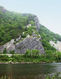
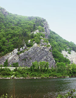
Most of the riding was gentle and rolling, save for one gut busting climb up and over to Millbrook Village (a preserved 1840s mill town) that sits in the shadow of the Kittaitinny Mountains. From there it is a gentle downhill run of about 10 miles to Delaware Water Gap, where we crossed the river for the first time into Pennsylvania, escorting BOB and Olga across the pedestrian walkway on Interstate 80. Route 611 on the PA side is much safer for bicyclists, and follows the river for 10 miles where it crosses back into New Jersey.
We came upon the town of Portland, PA. and intended to buy our evenings groceries, only to find that nearly every store on Main Street was closed or out of business. Curious, indeed. We went into one of the few open buildings, (which was the post office) to ask for suggestions of where to shop. We came to find out that Portland had been submerged in the flooding that occurred in July of this year. In fact, the post office had only reopened that very day, nearly 2 ½ months after the flooding occurred. Thousands of people had been evacuated from the area along the river, and there were a number of deaths linked to the flooding. And there we were, blithely rolling into town virtually unaware of the magnitude of the damage and destruction. Amazingly, the roads were still in adequate shape, although we feared for what we might encounter downstream. Not being able to find provisions close by, we ended up purchasing a foot long hero sandwich which we stowed for our supper. This was one of those days in which we didn’t have a clue where we would be staying. The map said that there was a campground near the river, but after calling their number we found that they had closed for the season. The next town was Belvidere NJ, and our hope was that maybe, maybe there was some lodging to be found there. The only hotel listed on the map seemed to be out of business. The sun was setting, we had ridden another 50+ mile day, and the prospects looked dim.
And even though Matt was born and raised there, he knew virtually nothing about the area of the state that the route would take us. “Heck, we never went to that part of Jersey”, he would say. “Why would you?” So you can imagine how surprised we were to discover that we found some of the most rural and idyllic areas to bicycle in that we had yet to encounter. If you learn nothing else from this blog, know this...New Jersey is the hidden gem along this route. The route basically follows the Delaware River from the New York border to Lambertville, approximately 120 miles. We found ourselves on tree lined rural roads that we literally had all to ourselves. There was one section in which we rode nearly 10 miles on a county highway without seeing a car, building or human being. This definitely was not the New Jersey depicted in the media.
 The route took us through the Delaware Water Gap National Recreation area, mainly on the Old Mine Road, so named because in American colonial times Dutch settlers carried copper ore from rich mines located in the area. Houses along the road became vital refuges and forts for settlers during the French and Indian War. George Washington's soldiers used the road and John Adams and Ben Franklin were frequent travelers. During the mid 19th Century part of the Old Mine Road became links in the Underground Railroad. In fact there are 90 sites in the DWGNRA that are on or eligible for the National Register being stabilized and restored for a wide variety of uses.
All of this was slated to be underwater. The National Recreation Area was originally conceived as an adjunct to "management" of the Delaware River. In 1960 the Army Corps of Engineers set upon a mission to build a dam at Tocks Island, just north of the Water Gap. This dam would control water levels for hydroelectric power generation and create a 37 mile lake for use as a reservoir. A smaller surrounding recreation area, to make a more "cost effective" dam, would be administered by the National Park Service.
Tens of millions of dollars were appropriated and work began to prepare the area for flooding. Three to five thousand dwellings were demolished. Some fifteen thousand people were displaced, many of whom represented 300 years and 13 generations of history and culture in the Upper Delaware Valley. A serene region of farms, hamlets and villages along a free flowing river was systematically dismantled as part of a plan that was eventually shelved. There was passionate opposition from many corners to the government's agenda. Some of the more visible historical homes were temporarily spared only to be destroyed by squatters and arsonists. For 18 years the valley was the site of a bizarre free-for-all with an unpredictable outcome.
Finally, in 1978 the project was deemed economically & environmentally unsound, and the government, instead of selling back the remaining 83 homes to original owners, transferred the properties to the National Park Service. The Delaware River was placed under the protection of the Scenic Rivers Act.
Most of the riding was gentle and rolling, save for one gut busting climb up and over to Millbrook Village (a preserved 1840s mill town) that sits in the shadow of the Kittaitinny Mountains. From there it is a gentle downhill run of about 10 miles to Delaware Water Gap, where we crossed the river for the first time into Pennsylvania, escorting BOB and Olga across the pedestrian walkway on Interstate 80. Route 611 on the PA side is much safer for bicyclists, and follows the river for 10 miles where it crosses back into New Jersey.
We came upon the town of Portland, PA. and intended to buy our evenings groceries, only to find that nearly every store on Main Street was closed or out of business. Curious, indeed. We went into one of the few open buildings, (which was the post office) to ask for suggestions of where to shop. We came to find out that Portland had been submerged in the flooding that occurred in July of this year. In fact, the post office had only reopened that very day, nearly 2 ½ months after the flooding occurred. Thousands of people had been evacuated from the area along the river, and there were a number of deaths linked to the flooding. And there we were, blithely rolling into town virtually unaware of the magnitude of the damage and destruction. Amazingly, the roads were still in adequate shape, although we feared for what we might encounter downstream. Not being able to find provisions close by, we ended up purchasing a foot long hero sandwich which we stowed for our supper. This was one of those days in which we didn’t have a clue where we would be staying. The map said that there was a campground near the river, but after calling their number we found that they had closed for the season. The next town was Belvidere NJ, and our hope was that maybe, maybe there was some lodging to be found there. The only hotel listed on the map seemed to be out of business. The sun was setting, we had ridden another 50+ mile day, and the prospects looked dim.
posted by Matt and Mary Ellen | 10:58 AM
![]()
![]()
0 Comments:
Post a Comment
<< Home