
The Land of the Trembling Earth
Outside of Odum, we were in store for a special treat. A little over 5 years ago, through the magic of the Internet, Matt had reconnected with Linda Kline, a childhood friend of his from his summer camp days who has livesd in Atlanta for the past 20 years. They had been conversing back and forth by email, and about 2 1/2 years ago concocted a plan to meet "somewhere in Georgia". We never realized at the time that "somewhere" meant a 4 hour drive from Atlanta, but as the day of the redezvous approached, we coordinated schedules and spent a wonderful evening together with Linda and her husband Walt. It's amazing how easily old friends can reconnect, and even after nearly 40 years feel comfortable and at ease with each other. That night we rode in their van through the Georgia countryside to a local backwoods steakhouse that reminded us of "The Marysville House" near our home in Helena. Down a clay road, no lighting or signs pointing the way...a true local hang out. Conversation came easily as we talked about our trip, their lives, and all of our collective hopes, dreams and desires for the future. It was another one of those special moments that we will remember about our trip, and look forward to hosting them in Montana in the near future.
The Biggest and the Best
The last big "landmark" for us in Georgia would be the Okefenokee Swamp. For two days we rode, observe the subtle changes in the landscape. Farm land and slight rolling hills gave way to scrub pine forests and logging trucks. It looked as if we had gone back into South Carolina, except that the trees were a heck of a lot skinnier, and the trucks were more numerous. We were making a bee line south to Folkston, which is the gateway community to the swamp and national wildlife refugee. We knew we were close when we started seeing billboards and alligator logos on the buildings. Folkston is a pleasant community that for us had special significance because it was the first "real" grocery store we had seen since Statesboro, some 200 miles ago. After chowing down on a hardy lunch buffet (let's just say we got our money's worth) at the local diner, we stocked up on our essentials. We did choose to forgo the alligator tail and frog legs that were on special in the meat department, opting instead for chicken. Anyway, doesn't it all taste like chicken?
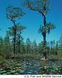
The Okefenokee swamp remains one of the oldest and most well preserved freshwater areas in America and extends 38 miles north to south and 25 miles east to west. Okefenokee is a vast bog inside a huge, saucer-shaped depression that was once part of the ocean floor. The swamp now lies 103 to 128 feet above mean sea level. Native Americans named the area "Okefenokee" the "Land of the Trembling Earth", because of the peat deposits (up to 15 feet thick) which cover much of the swamp floor. These deposits are so unstable in spots that trees and surrounding bushes tremble by stomping the surface. The slow-moving waters of the Okefenokee are tea-colored due to the tannic acid released from decaying vegetation. The principal outlet of the swamp, the Suwannee River(of Stephen Foster fame) , originates in the heart of the Okefenokee and drains southwest into the Gulf of Mexico. The swamp’s southeastern drainage to the Atlantic Ocean is the St. Mary’s River, which forms the boundary between Georgia and Florida. The swamp contains numerous islands and lakes, along with vast areas of non-forested habitat. Prairies cover about 60,000 acres of the swamp. Once forested, these expanses of marsh were created during periods of severe drought when fires burned out vegetation and the top layers of peat. The prairies harbor a variety of wading birds: herons, egrets, ibises, cranes, and bitterns.
Native Americans inhabited Okefenokee Swamp as early as 2500 B.C. The last tribe to seek sanctuary in the swamp were the Seminoles. Troops led by General Charles R. Floyd during the Second Seminole War, 1838-1842, ended the age of the native americans in the Okefenokee. The Suwanee Canal Company purchased 238,120 acres of the Okefenokee Swamp from the State of Georgia in 1891 to drain the swamp for rice, sugar cane, and cotton plantations. When this failed, the company began industrial wetland logging as a source of income. Captain Henry Jackson and his crews spent three years digging the Suwannee Canal 11.5 miles into the swamp. Economic recessions led to the company’s bankruptcy and eventual sale to Charles Hebard in 1901. Logging operations, focusing on the cypress, began in 1909 after a railroad was constructed on the northwest area of the swamp. More than 431 million board feet of timber were removed from the Okefenokee by 1927, when logging operations ceased. It became "protected" in 1937, and it is now one of the largest wilderness areas east of the Missisippi.By this time, numerous squatters and others had come to the swamp and even though they never really owned the property they were on, had to be removed from "their" property by the Federal government. It was a difficult time for all involved.
The best way to see the swamp is from a boat, and we signed up for a guided tour that tooks us through the historic Suwannee Canal drifting through a tangled forest of bay, cypress, pine and shrubs, then out into the open expanse of Chesser Prairie. Our guide Joey was a 6th generation "Swamper", and shared his knowledge of the swamp’s natural and cultural history, regaling us with interesting swamp stories and identify plants and wildlife along the way. We encountered egrets, herons, , red-shouldered hawks, and of course, numerous American alligators.
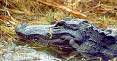 The American alligator is a member of the crocodile family, whose members are living fossils from the Age of Reptiles, having survived on earth for 200 million years. However, the alligator can be distinguished from the crocodile by its head shape and color. The crocodile has a narrower snout, and unlike the alligator, has teeth in the lower jaw which are visible even when its mouth is shut. In addition, adult alligators are black, while crocodiles are brownish in color.
Today, alligators are found throughout the Southeast, from the Carolinas to Texas and north to Arkansas. As during the Reptile Age, alligators live in wetlands, and it is this vital habitat that holds the key to their continued long-term survival. Alligators depend on the wetlands -- and in some ways the wetlands depend on them. As predators at the top of the food chain, they help control numbers of rodents and other animals that might overtax the marshland vegetation.
The alligator has a large, slightly rounded body, with thick limbs, a broad head, and a very powerful tail which it uses to propel itself through water. The tail accounts for half the alligator's length. While alligators move very quickly in water, they are generally slow-moving on land, although they can be quick for short distances. Alligators reach breeding maturity at about 8 to 13 years of age, at which time they are about 6 to 7 feet long. From then on, growth continues at a slower rate. Old males may grow to be 14 feet long and weigh up to 1,000 pounds during a lifespan of 30 or more years.
They'll eat eat just about anything, but primarily consume fish, turtles, and snails. Small animals that come to the water's edge to drink make easy prey for the voracious alligator.
The alligator's greatest value to the marsh and the other animals within it are the "gator holes" that many adults create and expand on over a period of years. An alligator uses its mouth and claws to uproot vegetation to clear out a space; then, shoving with its body and slashing with its powerful tail, it wallows out a depression that stays full of water in the wet season and holds water after the rains stop. During the dry season, and particularly during extended droughts, gator holes provide vital water for fish, insects, crustaceans, snakes, turtles, birds, and other animals in addition to the alligator itself. Sometimes, the alligator may expand its gator hole by digging beneath an overhanging bank to create a hidden den. After tunneling as far as 20 feet, it enlarges the end, making a chamber with a ceiling high enough above water level to permit breathing. This is not the alligator's nest but merely a way for the reptile to survive the dry season and winters.
And although you could have fooled us, the swamp and the entire southeast part of Georgia were in the grip of a rather serious drought. The water level of the swamp is totally dependent on rainfall to replenish itself, as no rivers flow into it, and was down significantly. Normal year to date rainfall is 50 inches, and as of now, heading into the "dry" season, only 35 inches has come down. The lack of hurricanes or major storms to visit the area was a welcome relief to homeowners (and their insurance companies) but had become a serious concern. The locals talked about how "brown" everything seemed to them, although to our untrained eye, it still looked mighty green to us.
We camped that night at a private campground just outside the refuge. We were a bit taken aback at the $25 price tag for the opportunity to pitch a tent, but in a way we had become spoiled. In all the states until Virginia, this would have been slightly belowthe average tariff. Once we left the Cape Hatteras region, prices of $15~$20 became the norm. In most of rural Georgia the prices had dropped to $7~$10, so our sticker shock needed to be put into perspective. After all, we were in a prime "tourist" locale, and with the Florida border just a few hours away, we figured that prices would be rising. The showers were clean, the crickets and frogs serenaded us, and with the moon nearly full, we cooked a meal repleat with fresh vegetables and a hardy ration of wine. We'd be crossing into Florida in the morning, and it began to really sink in that our journey was nearing it's end. The smell of the nearby swamp was noticeable. We had become familiar with, but never accustomed to the smell of "Swamp Gas" over the past month. "Swamp Gas", sometimes called "will-o-the wisp" or "foxfire" and even known in some quarters as "wetland flatulence" is a naturally occurring phenomena caused by decaying organic matter transforming into a gaseous state and on extremely rare occasions takes on certain properties of luminescence. In the 1950's many UFO skeptics used this uncommon swamp gas occurrence to dismiss numerous sightings of weird lights and objects in the sky. It reminded us of the odor we encountered along the banks of the Delaware River in New Jersey and Pennsylvania from the recent floods. It's distinct and definitely not a pleasing smell, put something you get use to (or "tune out) with time.
With standard time now back into effect, the sky gets light enough to start coffee and get breakfast going at around 6:15 or so. We broke camp by 8:00 and headed due south to St. George, located in the middle of the Georgia "panhandle". Actually, when you look at the map, Georgia is seems shaped more like a large kitchen cleaver, with a little finger of land jutting out along the Florida border forming the handle. The aforementiioned St. Mary's River that flows out of the swamp forms the southern border of the state, and after refueling at Rhoda's Cafe on a cheese omelet and grits (along with 38 cent coffee) we turned due east to cross into the "Flowery Land" and our final state of the trip. We were psyched, proud and exhilarated. Florida was ours for the taking! During our journey many folks commented to us that it should be easy, because, after all, from Maine to Florida is all downhill on the map. Now we were beginning to believe that maybe, just maybe, they were right.
The Biggest and the Best
The last big "landmark" for us in Georgia would be the Okefenokee Swamp. For two days we rode, observe the subtle changes in the landscape. Farm land and slight rolling hills gave way to scrub pine forests and logging trucks. It looked as if we had gone back into South Carolina, except that the trees were a heck of a lot skinnier, and the trucks were more numerous. We were making a bee line south to Folkston, which is the gateway community to the swamp and national wildlife refugee. We knew we were close when we started seeing billboards and alligator logos on the buildings. Folkston is a pleasant community that for us had special significance because it was the first "real" grocery store we had seen since Statesboro, some 200 miles ago. After chowing down on a hardy lunch buffet (let's just say we got our money's worth) at the local diner, we stocked up on our essentials. We did choose to forgo the alligator tail and frog legs that were on special in the meat department, opting instead for chicken. Anyway, doesn't it all taste like chicken?
The Okefenokee swamp remains one of the oldest and most well preserved freshwater areas
 in America and extends 38 miles north to south and 25 miles east to west. Okefenokee is a vast bog inside a huge, saucer-shaped depression that was once part of the ocean floor. The swamp now lies 103 to 128 feet above mean sea level. Native Americans named the area "Okefenokee" the "Land of the Trembling Earth", because of the peat deposits (up to 15 feet thick) which cover much of the swamp floor. These deposits are so unstable in spots that trees and surrounding bushes tremble by stomping the surface. The slow-moving waters of the Okefenokee are tea-colored due to the tannic acid released from decaying vegetation. The principal outlet of the swamp, the Suwannee River(of Stephen Foster fame) , originates in the heart of the Okefenokee and drains southwest into the Gulf of Mexico. The swamp’s southeastern drainage to the Atlantic Ocean is the St. Mary’s River, which forms the boundary between Georgia and Florida. The swamp contains numerous islands and lakes, along with vast areas of non-forested habitat. Prairies cover about 60,000 acres of the swamp. Once forested, these expanses of marsh were created during periods of severe drought when fires burned out vegetation and the top layers of peat. The prairies harbor a variety of wading birds: herons, egrets, ibises, cranes, and bitterns.
Native Americans inhabited Okefenokee Swamp as early as 2500 B.C. The last tribe to seek sanctuary in the swamp were the Seminoles. Troops led by General Charles R. Floyd during the Second Seminole War, 1838-1842, ended the age of the native americans in the Okefenokee. The Suwanee Canal Company purchased 238,120 acres of the Okefenokee Swamp from the State of Georgia in 1891 to drain the swamp for rice, sugar cane, and cotton plantations. When this failed, the company began industrial wetland logging as a source of income. Captain Henry Jackson and his crews spent three years digging the Suwannee Canal 11.5 miles into the swamp. Economic recessions led to the company’s bankruptcy and eventual sale to Charles Hebard in 1901. Logging operations, focusing on the cypress, began in 1909 after a railroad was constructed on the northwest area of the swamp. More than 431 million board feet of timber were removed from the Okefenokee by 1927, when logging operations ceased. It became "protected" in 1937, and it is now one of the largest wilderness areas east of the Missisippi.By this time, numerous squatters and others had come to the swamp and even though they never really owned the property they were on, had to be removed from "their" property by the Federal government. It was a difficult time for all involved.
The best way to see the swamp is from a boat, and we signed up for a guided tour that tooks us through the historic Suwannee Canal drifting through a tangled forest of bay, cypress, pine and shrubs, then out into the open expanse of Chesser Prairie. Our guide Joey was a 6th generation "Swamper", and shared his knowledge of the swamp’s natural and cultural history, regaling us with interesting swamp stories and identify plants and wildlife along the way. We encountered egrets, herons, , red-shouldered hawks, and of course, numerous American alligators.
 The American alligator is a member of the crocodile family, whose members are living fossils from the Age of Reptiles, having survived on earth for 200 million years. However, the alligator can be distinguished from the crocodile by its head shape and color. The crocodile has a narrower snout, and unlike the alligator, has teeth in the lower jaw which are visible even when its mouth is shut. In addition, adult alligators are black, while crocodiles are brownish in color.
Today, alligators are found throughout the Southeast, from the Carolinas to Texas and north to Arkansas. As during the Reptile Age, alligators live in wetlands, and it is this vital habitat that holds the key to their continued long-term survival. Alligators depend on the wetlands -- and in some ways the wetlands depend on them. As predators at the top of the food chain, they help control numbers of rodents and other animals that might overtax the marshland vegetation.
The alligator has a large, slightly rounded body, with thick limbs, a broad head, and a very powerful tail which it uses to propel itself through water. The tail accounts for half the alligator's length. While alligators move very quickly in water, they are generally slow-moving on land, although they can be quick for short distances. Alligators reach breeding maturity at about 8 to 13 years of age, at which time they are about 6 to 7 feet long. From then on, growth continues at a slower rate. Old males may grow to be 14 feet long and weigh up to 1,000 pounds during a lifespan of 30 or more years.
They'll eat eat just about anything, but primarily consume fish, turtles, and snails. Small animals that come to the water's edge to drink make easy prey for the voracious alligator.
The alligator's greatest value to the marsh and the other animals within it are the "gator holes" that many adults create and expand on over a period of years. An alligator uses its mouth and claws to uproot vegetation to clear out a space; then, shoving with its body and slashing with its powerful tail, it wallows out a depression that stays full of water in the wet season and holds water after the rains stop. During the dry season, and particularly during extended droughts, gator holes provide vital water for fish, insects, crustaceans, snakes, turtles, birds, and other animals in addition to the alligator itself. Sometimes, the alligator may expand its gator hole by digging beneath an overhanging bank to create a hidden den. After tunneling as far as 20 feet, it enlarges the end, making a chamber with a ceiling high enough above water level to permit breathing. This is not the alligator's nest but merely a way for the reptile to survive the dry season and winters.
And although you could have fooled us, the swamp and the entire southeast part of Georgia were in the grip of a rather serious drought. The water level of the swamp is totally dependent on rainfall to replenish itself, as no rivers flow into it, and was down significantly. Normal year to date rainfall is 50 inches, and as of now, heading into the "dry" season, only 35 inches has come down. The lack of hurricanes or major storms to visit the area was a welcome relief to homeowners (and their insurance companies) but had become a serious concern. The locals talked about how "brown" everything seemed to them, although to our untrained eye, it still looked mighty green to us.
We camped that night at a private campground just outside the refuge. We were a bit taken aback at the $25 price tag for the opportunity to pitch a tent, but in a way we had become spoiled. In all the states until Virginia, this would have been slightly belowthe average tariff. Once we left the Cape Hatteras region, prices of $15~$20 became the norm. In most of rural Georgia the prices had dropped to $7~$10, so our sticker shock needed to be put into perspective. After all, we were in a prime "tourist" locale, and with the Florida border just a few hours away, we figured that prices would be rising. The showers were clean, the crickets and frogs serenaded us, and with the moon nearly full, we cooked a meal repleat with fresh vegetables and a hardy ration of wine. We'd be crossing into Florida in the morning, and it began to really sink in that our journey was nearing it's end. The smell of the nearby swamp was noticeable. We had become familiar with, but never accustomed to the smell of "Swamp Gas" over the past month. "Swamp Gas", sometimes called "will-o-the wisp" or "foxfire" and even known in some quarters as "wetland flatulence" is a naturally occurring phenomena caused by decaying organic matter transforming into a gaseous state and on extremely rare occasions takes on certain properties of luminescence. In the 1950's many UFO skeptics used this uncommon swamp gas occurrence to dismiss numerous sightings of weird lights and objects in the sky. It reminded us of the odor we encountered along the banks of the Delaware River in New Jersey and Pennsylvania from the recent floods. It's distinct and definitely not a pleasing smell, put something you get use to (or "tune out) with time.
With standard time now back into effect, the sky gets light enough to start coffee and get breakfast going at around 6:15 or so. We broke camp by 8:00 and headed due south to St. George, located in the middle of the Georgia "panhandle". Actually, when you look at the map, Georgia is seems shaped more like a large kitchen cleaver, with a little finger of land jutting out along the Florida border forming the handle. The aforementiioned St. Mary's River that flows out of the swamp forms the southern border of the state, and after refueling at Rhoda's Cafe on a cheese omelet and grits (along with 38 cent coffee) we turned due east to cross into the "Flowery Land" and our final state of the trip. We were psyched, proud and exhilarated. Florida was ours for the taking! During our journey many folks commented to us that it should be easy, because, after all, from Maine to Florida is all downhill on the map. Now we were beginning to believe that maybe, just maybe, they were right.
posted by Matt and Mary Ellen | 11:54 AM
![]()
![]()
0 Comments:
Post a Comment
<< Home