
A New Beginning
Generally speaking, a tandem bike doesn’t require any more maintenance than a bicycle built for one. Cables are longer, there are more chains to fuss with, and brake pads do wear more quickly. Other than that, the differences begin to blur. Oh yes, there’s one more thing...the rear tire wears out faster on a tandem. Knowledgeable bike folks recommend that the tires be rotated (front to back) at about 1000 miles and be replaced at the next “service interval”. Matt had commented more than once that we should probably rotate the tires, but things had been going so well for us that he just kept putting it off. Life teaches you that it pays to do preventive maintenance with any mechanical device as sooner or later you are going to have to deal with it. So it should come as no surprise that we awoke to find that our rear tire had gone flat once again.
Common decency and decorum prevent us from repeating what was said at the time. We had one new tube and one that had been patched from the previous day. It seemed peculiar that we rode for a full day with not even a hint of a leak, but there we were, confronted with the brutal reality of a tire flatter than a pancake. Not knowing what was wrong, it was time to throw in the towel and get a new tire. The problem of course was that the closest bike shop was about 8 miles down the road in Palm Beach. Matt put air back into the tire again and it seemed to hold. Maybe he had forgotten to tighten the valve and the air leaked out overnight. It’s amazing what you can talk yourself into when you engage in wishful thinking. Since our “pump and ride” method worked so well a few days before, we decided to give it a go. If we could cycle 3 or 4 miles, stop and pump it up, we’d be at the bike shop without the hassle of changing the tire again. It certainly was worth a try.
We rode over the causeway into Riviera Beach and made it 5 miles before we needed to refill. And that was a good thing because while Riviera Beach is located next to one of the swankiest communities in the US, it is not a place you want to be hanging around, even in the morning. By now Matt had gotten the pump routine down, putting in 150 strokes to get the tire back to normal. Feeling pretty sure that we pushed on and entered West Palm Beach. There’s an old saying that “De Nile just ain’t a river in Egypt“. We were definitely in denial about our rear tire.
This time, we didn’t even go a mile before the tire went totally flat. We stood by our wounded bike and reviewed our alternatives. The closest bike shop was maybe two miles away across another bridge. We could push the bike and walk. Or, we could hitch a ride from some kind stranger. Hailing a cab was also a consideration. After a few minutes we decided to remove the tire one more time and see if anything could be salvaged. We still had one good (albeit patched) tube, and if we could just stay inflated for 15 minutes or so, our day would be considerably brighter. Once again we disconnected BOB, unhooked the panniers, and flipped Olga over on her saddles so Matt could remove the rear wheel. This time he inspected the tire with great deliberation and care. After a minute or two of silence he had a “Eureka” moment. Rubbing his thumb slowly over the inside of the tire, he discovered that the tire casing had worn through, and what he thought to be a shard of metal or piece of wire was actually the tire unraveling on itself. That explained why it kept going flat. The poor tire had reached the end of its service life and should have been replaced hundreds of miles ago. So what to do now?
All things considered, if you were going to have a meltdown, we were in a relatively convenient location. Worse case scenario was a few hours hassle, but we still would get to Mom’s house by the end of the day. Matt spent some time rummaging through our spare part/tool kit to see if there was anything he could come up with to eek a few more miles of life out of the tire. The solution was anything but elegant, and we would advise that you don’t try this at home. We had brought along replacement foam insert pads for our helmets that had been long forgotten and stayed hidden away in a zip lock bag. Matt conjured up a plan to put the pads on the inside of the tire wherever he could feel and uneven surface, refill the tire with our remaining tube, and pedal like hell to the bike shop. Why not?
We rode like demons across the Flagler Bridge into downtown Palm Beach. Some of the names may have changed but the very essence of this highly coveted 14-mile-long strip of paradise has not. In the old days, Palm Beach was the backdrop of an ultra-elite social season originally only 10 weeks long - mid-December to Feb. 23, the day after the George Washington Birthday Ball at Henry Flagler's mansion. When the social season ended in Palm Beach, it shifted and scattered north to New York (the Hamptons), Massachusetts (Nantucket, Martha's Vineyard), Rhode Island (Newport) and Maine (Bar Harbor), and to the mid-western mansions of the world's most affluent leaders of industry. And while changing times and the advent of air conditioning have quadrupled the length of the season, now from November to April, Palm Beach has kept pace.
Henry Flagler (remember him from St. Augustine?) saw a golden opportunity to develop the east coast of Florida. After visiting the area, he became enamored with its temperate climate and saw that hotels and a good transportation system would lure winter visitors. In 1893 he purchased 140 acres on the Atlantic Ocean of what was then called Palm Beach, named because of the many cabbage palms that grew along the beach. In 1894, Henry Flagler opened his first Palm Beach resort, The Royal Poinciana, on Lake Worth. At the time, it was the only oceanfront hotel south of Daytona Beach. Two years later, he built the Port of Palm Beach, consisting of a pier 1,000 feet long to accommodate steamships traveling to Nassau, Havana, and Key West. To keep his golfing guests happy, Henry Flagler then added the first 9 hole course in Florida, along with The Poinciana Golf Clubhouse. Today, it is the location of the Centennial restaurant in The Breakers Hotel, the name taken on by The Royal Poinciana. Legend has it that guests kept requesting a room “by the breakers”, referring to the oceanfront accommodations.
By the turn of the century, Palm Beach was celebrated as the winter vacation grounds for the wealthy. The Royal Poinciana resort was enlarged to twice its size. In 1903, The Breakers Hotel burned to the ground. Mr. Flagler rebuilt it, larger and more attractive. He even had his railroad come right to the hotel's entrance. In 1925, the hotel burned down again. In less than a year, the Flagler heirs reconstructed it into the complex that exists today. Between 1920 and 1927, the population of Palm Beach increased four fold. The community saw new schools, an increase in farming, sugar businesses, hotels, theatres, and services. Hurricanes in 1926 and 1928 brought considerable property damage. To make matters worse, the stock market crashed in 1929, reducing property values in half. It took many years to regain the loss. World War II brought the military into place along Florida's coastline to watch for enemy submarines and U-boats. During the 1950's, veterans from the war began moving into the area. This began a new era in the development of Palm Beach and neighboring communities.
For a while, life was quiet and the heady days of lavish parties and exclusive gambling was a thing of the past. However, it never died. It was just asleep, waiting for the new social climate to awaken, and it has. Today, a revitalization program for the downtown district is nearly complete. Mansions built by industrial magnates in the 1920's are museums. Whitehall is a magnificent example of the opulence of the era. Many of the smaller neighborhood homes are now charming bed and breakfasts. Grand hotels cater to both the business and pleasure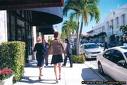 traveler. Worth Avenue is once again an exclusive shopping boulevard, lined with restaurants, art galleries, antique stores and boutiques. Palm Beach is still the winter vacationland of many, whether wealthy or not so wealthy. Visitors flock to this historic city all year long. The price of real estate is skyrocketing again.
We located the bike shop on Sunrise Ave., next to the French Bakery and around the corner from a number of highly fashionable haberdasheries and jewelry stores. Finally Olga got some new shoes. Within 15 minutes we were back on A1A cruising past the remarkable Mediterranean inspired mansions... astonishing for their size, landscaping, architecture and sheer grandeur. This wasn’t how the “other half” lives. We were seeing the creme de la creme, with each home more spectacular than the next.
We turned past Mar-A-Lago, the enormous Moorish-Mediterranean estate of Margery Merriweather Post that now belongs to Donald Trump. It's an ultra exclusive club; membership is $750,000 a year. That's just to get in. Every service and activity is extra. If you have to ask, you can’t afford it. We rode on through a corridor of high rise apartments and homes of the well to do, with a golf course or beach park interspersed along the way. Although the towns had different names, they were indistinguishable from one another.
Since we didn’t have to stop anymore to pump life back into the tire, we were making good time. We’d be at Mom’s house by 3 PM, just as we had planned at the start of the day. It was now our turn to find out what it felt like to finish a 70 day bike trip.
We were often asked along the way if we had ever done anything like this before. While we’ve toured over the years, our longest trip up to this point had been 10 days. But by now we didn’t feel that what we were doing was extraordinary. We can still remember people in Bar Harbor shaking their heads in disbelief when we told them we were headed to Florida on a bike. The further we went, the more believable it became and we knew after a few weeks that baring injury or a calamity beyond our control, we’d reach our goal. There never was any doubt in our minds. When folks wondered what it was like to ride day after day, our response became “it’s like eating an elephant one bite at a time.” You take it slow, live in the moment, and don’t fret over things you can’t control.
For Mary Ellen, the trip began the day after she retired as administrator of Head Start in Helena. She felt it was a perfect way to ease into her life beyond work. Matt, on the other hand, will be returning to his job on December 11, working through August of next year before moving on to new challenges. For him, the trip was a culmination of a process that began some 30 years ago when he made an early course correction in his life as well as the fulfillment of an affirmation he had made with himself some 5 years ago.
At the start of the blog we shared some of the reasons as to why we wanted to undertake this journey. We’ve learned once again that ordinary people are capable of doing remarkable things. Both of us feel that it we are most fortunate. We enjoy good health, have adequate financial resources, are blessed with supportive friends and family, live in a great country, and after 31 years of being together and sharing 70 days of 24/7 in exceptional circumstances, we love and respect one another.
It’s been a rare and special privilege to ride with Olga and BOB. We had often thought of what it would feel like at trails end. As we talked about it, we have come to understand that while this trip may be over, the journey into the next phase of our lives has just begun. At the end, there’s a new beginning.
The odometer read 2882.2 miles when we put on the brakes for the last time in Mom’s driveway . We were all smiles when she came out to greet us. Parking Olga and BOB next to the garage, we started to unload our gear. That celebratory pina colada we had been fantasizing on for over 2 months was sure going to taste good.
Common decency and decorum prevent us from repeating what was said at the time. We had one new tube and one that had been patched from the previous day. It seemed peculiar that we rode for a full day with not even a hint of a leak, but there we were, confronted with the brutal reality of a tire flatter than a pancake. Not knowing what was wrong, it was time to throw in the towel and get a new tire. The problem of course was that the closest bike shop was about 8 miles down the road in Palm Beach. Matt put air back into the tire again and it seemed to hold. Maybe he had forgotten to tighten the valve and the air leaked out overnight. It’s amazing what you can talk yourself into when you engage in wishful thinking. Since our “pump and ride” method worked so well a few days before, we decided to give it a go. If we could cycle 3 or 4 miles, stop and pump it up, we’d be at the bike shop without the hassle of changing the tire again. It certainly was worth a try.
We rode over the causeway into Riviera Beach and made it 5 miles before we needed to refill. And that was a good thing because while Riviera Beach is located next to one of the swankiest communities in the US, it is not a place you want to be hanging around, even in the morning. By now Matt had gotten the pump routine down, putting in 150 strokes to get the tire back to normal. Feeling pretty sure that we pushed on and entered West Palm Beach. There’s an old saying that “De Nile just ain’t a river in Egypt“. We were definitely in denial about our rear tire.
This time, we didn’t even go a mile before the tire went totally flat. We stood by our wounded bike and reviewed our alternatives. The closest bike shop was maybe two miles away across another bridge. We could push the bike and walk. Or, we could hitch a ride from some kind stranger. Hailing a cab was also a consideration. After a few minutes we decided to remove the tire one more time and see if anything could be salvaged. We still had one good (albeit patched) tube, and if we could just stay inflated for 15 minutes or so, our day would be considerably brighter. Once again we disconnected BOB, unhooked the panniers, and flipped Olga over on her saddles so Matt could remove the rear wheel. This time he inspected the tire with great deliberation and care. After a minute or two of silence he had a “Eureka” moment. Rubbing his thumb slowly over the inside of the tire, he discovered that the tire casing had worn through, and what he thought to be a shard of metal or piece of wire was actually the tire unraveling on itself. That explained why it kept going flat. The poor tire had reached the end of its service life and should have been replaced hundreds of miles ago. So what to do now?
All things considered, if you were going to have a meltdown, we were in a relatively convenient location. Worse case scenario was a few hours hassle, but we still would get to Mom’s house by the end of the day. Matt spent some time rummaging through our spare part/tool kit to see if there was anything he could come up with to eek a few more miles of life out of the tire. The solution was anything but elegant, and we would advise that you don’t try this at home. We had brought along replacement foam insert pads for our helmets that had been long forgotten and stayed hidden away in a zip lock bag. Matt conjured up a plan to put the pads on the inside of the tire wherever he could feel and uneven surface, refill the tire with our remaining tube, and pedal like hell to the bike shop. Why not?
We rode like demons across the Flagler Bridge into downtown Palm Beach. Some of the names may have changed but the very essence of this highly coveted 14-mile-long strip of paradise has not. In the old days, Palm Beach was the backdrop of an ultra-elite social season originally only 10 weeks long - mid-December to Feb. 23, the day after the George Washington Birthday Ball at Henry Flagler's mansion. When the social season ended in Palm Beach, it shifted and scattered north to New York (the Hamptons), Massachusetts (Nantucket, Martha's Vineyard), Rhode Island (Newport) and Maine (Bar Harbor), and to the mid-western mansions of the world's most affluent leaders of industry. And while changing times and the advent of air conditioning have quadrupled the length of the season, now from November to April, Palm Beach has kept pace.
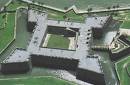
Henry Flagler (remember him from St. Augustine?) saw a golden opportunity to develop the east coast of Florida. After visiting the area, he became enamored with its temperate climate and saw that hotels and a good transportation system would lure winter visitors. In 1893 he purchased 140 acres on the Atlantic Ocean of what was then called Palm Beach, named because of the many cabbage palms that grew along the beach. In 1894, Henry Flagler opened his first Palm Beach resort, The Royal Poinciana, on Lake Worth. At the time, it was the only oceanfront hotel south of Daytona Beach. Two years later, he built the Port of Palm Beach, consisting of a pier 1,000 feet long to accommodate steamships traveling to Nassau, Havana, and Key West. To keep his golfing guests happy, Henry Flagler then added the first 9 hole course in Florida, along with The Poinciana Golf Clubhouse. Today, it is the location of the Centennial restaurant in The Breakers Hotel, the name taken on by The Royal Poinciana. Legend has it that guests kept requesting a room “by the breakers”, referring to the oceanfront accommodations.
By the turn of the century, Palm Beach was celebrated as the winter vacation grounds for the wealthy. The Royal Poinciana resort was enlarged to twice its size. In 1903, The Breakers Hotel burned to the ground. Mr. Flagler rebuilt it, larger and more attractive. He even had his railroad come right to the hotel's entrance. In 1925, the hotel burned down again. In less than a year, the Flagler heirs reconstructed it into the complex that exists today. Between 1920 and 1927, the population of Palm Beach increased four fold. The community saw new schools, an increase in farming, sugar businesses, hotels, theatres, and services. Hurricanes in 1926 and 1928 brought considerable property damage. To make matters worse, the stock market crashed in 1929, reducing property values in half. It took many years to regain the loss. World War II brought the military into place along Florida's coastline to watch for enemy submarines and U-boats. During the 1950's, veterans from the war began moving into the area. This began a new era in the development of Palm Beach and neighboring communities.
For a while, life was quiet and the heady days of lavish parties and exclusive gambling was a thing of the past. However, it never died. It was just asleep, waiting for the new social climate to awaken, and it has. Today, a revitalization program for the downtown district is nearly complete. Mansions built by industrial magnates in the 1920's are museums. Whitehall is a magnificent example of the opulence of the era. Many of the smaller neighborhood homes are now charming bed and breakfasts. Grand hotels cater to both the business and pleasure
 traveler. Worth Avenue is once again an exclusive shopping boulevard, lined with restaurants, art galleries, antique stores and boutiques. Palm Beach is still the winter vacationland of many, whether wealthy or not so wealthy. Visitors flock to this historic city all year long. The price of real estate is skyrocketing again.
We located the bike shop on Sunrise Ave., next to the French Bakery and around the corner from a number of highly fashionable haberdasheries and jewelry stores. Finally Olga got some new shoes. Within 15 minutes we were back on A1A cruising past the remarkable Mediterranean inspired mansions... astonishing for their size, landscaping, architecture and sheer grandeur. This wasn’t how the “other half” lives. We were seeing the creme de la creme, with each home more spectacular than the next.
We turned past Mar-A-Lago, the enormous Moorish-Mediterranean estate of Margery Merriweather Post that now belongs to Donald Trump. It's an ultra exclusive club; membership is $750,000 a year. That's just to get in. Every service and activity is extra. If you have to ask, you can’t afford it. We rode on through a corridor of high rise apartments and homes of the well to do, with a golf course or beach park interspersed along the way. Although the towns had different names, they were indistinguishable from one another.
Since we didn’t have to stop anymore to pump life back into the tire, we were making good time. We’d be at Mom’s house by 3 PM, just as we had planned at the start of the day. It was now our turn to find out what it felt like to finish a 70 day bike trip.
We were often asked along the way if we had ever done anything like this before. While we’ve toured over the years, our longest trip up to this point had been 10 days. But by now we didn’t feel that what we were doing was extraordinary. We can still remember people in Bar Harbor shaking their heads in disbelief when we told them we were headed to Florida on a bike. The further we went, the more believable it became and we knew after a few weeks that baring injury or a calamity beyond our control, we’d reach our goal. There never was any doubt in our minds. When folks wondered what it was like to ride day after day, our response became “it’s like eating an elephant one bite at a time.” You take it slow, live in the moment, and don’t fret over things you can’t control.
For Mary Ellen, the trip began the day after she retired as administrator of Head Start in Helena. She felt it was a perfect way to ease into her life beyond work. Matt, on the other hand, will be returning to his job on December 11, working through August of next year before moving on to new challenges. For him, the trip was a culmination of a process that began some 30 years ago when he made an early course correction in his life as well as the fulfillment of an affirmation he had made with himself some 5 years ago.
At the start of the blog we shared some of the reasons as to why we wanted to undertake this journey. We’ve learned once again that ordinary people are capable of doing remarkable things. Both of us feel that it we are most fortunate. We enjoy good health, have adequate financial resources, are blessed with supportive friends and family, live in a great country, and after 31 years of being together and sharing 70 days of 24/7 in exceptional circumstances, we love and respect one another.
It’s been a rare and special privilege to ride with Olga and BOB. We had often thought of what it would feel like at trails end. As we talked about it, we have come to understand that while this trip may be over, the journey into the next phase of our lives has just begun. At the end, there’s a new beginning.
The odometer read 2882.2 miles when we put on the brakes for the last time in Mom’s driveway . We were all smiles when she came out to greet us. Parking Olga and BOB next to the garage, we started to unload our gear. That celebratory pina colada we had been fantasizing on for over 2 months was sure going to taste good.
posted by Matt and Mary Ellen | 10:05 AM
|
5 comments
![]()
![]()
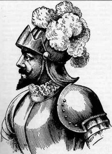 According to tradition, the natives of Hispaniola, Puerto Rico and Cuba told the early Spanish explorers that in Bimini, a land to the north, there was a river, spring or fountain where waters had such miraculous curative powers that any old person who bathed in them would regain his youth. Juan Ponce de Leon (1460-1521), who had been with Columbus on his second voyage in 1493 and who had later conquered and become governor of Puerto Rico, is supposed to have learned of the fable from the Indians. The fable was not new, and probably Ponce de Leon was vaguely cognizant of the fact that such waters had been mentioned by medieval writers, and that Alexander the Great had searched for such waters in eastern Asia. A similar legend was known to the Polynesians, whose tradition located the fountain of youth in Hawaii.

