Olga and Bob's Most Excellent Adventure

Olga (our trusty tandem bike) and BOB (our trailer) will take us from Maine to Florida along the Adventure Cycling Associations' East Coast Route. The trip begins on August 30th and will end sometime in early November. We'll be blogging along the route so check back often for the latest posting. If you want to read this in chronological order, start from the bottom and work your way up. Otherwise, it may not make sense. See you on the trail!

Name:
Location: Helena, Montana, United States

In the Spanish speaking world south of the US border they have a term for people like us..."jubliados". It implies that the later years of ones life is to explore, discover and expand their horizons. We embrace the concept and hope to share some insights with you.

Saturday, September 30, 2006

Reflections

At the mid point of our journey, we’ve had a relaxing four days to recharge our internal batteries, do preventive maintenance on Olga, send some unneeded items home, and replenish supplies. We also spent time sorting our photos as well as catching up with emails from family, friends and surprisingly, total strangers who had come to find out about the blog. Apparently, Adventure Cycling ran a notice about our trip in one of their publications, and we have been both amazed and slightly overwhelmed by the response.

Arriving in DC having regular access to a computer, we were stunned to find nearly 20 emails in our inbox from individuals we’ve never met. Many offered encouraging words, some invited us to stay with them, and one asked us to meet with their bike club when we were passing through their town. WOW! It still gives us goose bumps thinking about it. We answered all the best we could, and realized that in the electronic age we live in, people can connect in new and unexpected ways.

While getting caught up on our chores, we’ve had time to reflect on the experiences of the past few weeks. For what their worth…

- The people of our country are kind and generous. We’ve been treated well everwhere we’ve been, and folks have gone out of their way to help us out.

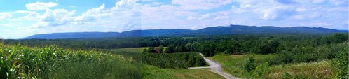
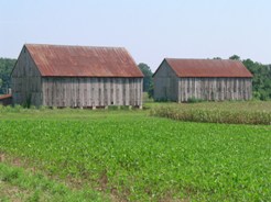
- We live in a land of incredible wealth, both material and natural beauty. We know that there is poverty and suffering all around, but traveling at 8~9 miles per hour, we’ve looked into peoples homes and lives. We can see how they live, the cars they drive, what the roads and communities look like. And we like what we see.

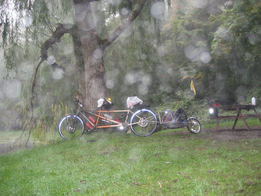
- Traveling by tandem is a special treat. We’re able to communicate and work together, tell jokes, and enjoy the small triumphs of conquering each hill as a team. We laugh, sweat, and work as one. It is an extraordinary experience to share.

- There are lots of lawns to be mowed in the East. In fact, if you had to ask us what the most common sound we’ve heard on the trail, it is that of lawnmowers…riding, power, push mowers, you name it, we’ve seen and heard them. There are even stores where all they sell are lawnmowers. This is not something you see back from where we come from.

- The New England and Mid Atlantic states are exceptionally green and rich in foliage. Some rain was to be expected, and on the whole we have been prepared for it. What has come as a surprise is how damp everything is. New Jersey seemed tropical, with morning dew so heavy that it soaked our tent fly like a steady rain storm. Sometimes we rode through mist…not rain, but mist. The air would feel like an oversaturated sponge, dripping its excessive moisture on us. While we haven’t had to use moisturizers or skin lotion like we do back home, this would take some getting used to on a regular basis.

- As we had hoped, America’s colonial history and early beginnings have come alive for us. We’ve learned so much about our countries origin, and anticipate learning even more as we travel south through the Virginia plantation region and Civil War battlefields. Every place, every town, has a special story. It’s a treat to see it from our bike.

- It's been a pleasant surprise to spend time with some of our relatives. It's not something we had really planned on, but their support and interest in us has been uplifting and we appreciate the effort they made to spend time with us. Thanks.

- The ACA route is a gem. The route selection has been superb, and in those situations where we have had to ride in traffic, they’ve done a good job on directing us to the safest roads possible. However, as our suburban areas continue to expand, it will be a challenge to find roads that maintain their rural characteristics.

- Related to that, many folks in the rural East are concerned about growth. In a number of communities we passed through, we saw signs and placards declaring “No to Expansion”, or “Smart Growth” or “Maintain our Rural Character”. Heretofore we had never given any thought about growth issues in the East, assuming that this was more a Western phenomena. But people are rightly concerned about how they are beginning to loose their rural nature, and seem to want to do something about it. There are a surprising number of public land and farm trusts. We saw numerous examples of tracts of land that had been preserved in perpetuity, for future generations to enjoy. It will be interesting to see how all this plays out.

- A great number of people we meet talk about their own dreams and aspirations. What we know is this…you gravitate to what is uppermost in your mind. Five years ago we decided to take a long distance bike trip, and it became our driving force. And here we are, at the mid-way point of fulfilling that dream. Our advice is to live your dreams. Think it, plan it, and alter it as need be, but live it. Approaching life with a positive mental attitude and sense of purpose makes it happen. Like they say in the Nike commercial…Just Do It.

Tomorrow we head back out on the trail. We intend to ride on to Richmond and then take a detour to Colonial Williamsburg, Jamestown, and Yorktown. Even though it is not on the route, it’s an opportunity too good to pass up. We’ve enjoyed our respite, spending time with Donna, Brian, as well as our niece Lauren and nephew Mark. They have been marvelous hosts, and have helped make us feel right at home. But we’re anxious to get going again. Olga is in fine shape, with new brake pads and shift cables. All of BOB’s nuts and bolts have been tightened, and it’s time to be moving on. We’re venturing into uncharted territory for the two of us, and look forward to what we will discover down the road. It’s time to once again proceed on.

The March on Washington


Maryland is classified by the U.S. Census bureau as a South-Atlantic state. It was the seventh state to ratify the Constitution, and is nicknamed the Old Line State and the Free State. Its history as a border state has led it to exhibit characteristics of both the Northern and Southern regions of the United States. For the first time, we start hearing what sounded like Southern accents. It was the third distinctive change in pronunciation we have noted; New England, NY/NJ, and now this. It will be interest to see how it changes even more as we pedal further South. Most of our route took us through Northern Maryland, which is famous as horse country.

In fact, we were riding on part of the designated National Scenic byway known as “Steeplechase Country”. The valleys and vistas of this route create the illusion that this byway has taken you into the English countryside. Fox hunting is still popular here, and the hunt races, as they're called, attract the country's best steeplechasers.

We also found the roadways to be in excellent shape, in fact the best we encountered so far. The terrain continued to become more “biker friendly”, although there were a few climbs on each day that tested our mettle. A curiosity for us was that Maryland's plant life is abundant and healthy. A good dose of annual precipitation help to support many types of plants, including seagrass, bamboo and various reeds at the smaller end of the spectrum to the gigantic Wye Oak, a huge example of White Oak, the state tree, which can grow in excess of 70 ft tall. This part of the state gets ample rain, and we had our share of it.

Curiously, even though we were skirting the city of Baltimore by only 20~30 miles, there were virtually no options available for overnight lodging. The dilemma, which we faced before, was that designated campsites were non-existent. Furthermore, we could not find any B&B’s in the area. The motels that did exist were 10 or more miles off route and would take us into heavily populated and high traffic areas. We opted to stay on the trail and try our luck. Around 5 PM we arrived in the small village of Corbett which is located at the bottom of a ravine along the aptly named Cold Bottom Creek. We went door to door, trying to find someone and ask for permission to camp on their land. No one answered. Finally, we took matters into our own hands and found an old trail that followed the creek. We pushed our bike down the trail until we couldn’t see the road any more, and called it good. Technically, we were trespassing, but our rationale was that we had indeed tried to ask permission, and if perchance the local officials found us, at least we would spend a night under roof at the expense of the county. Thankfully, the evening passed uneventfully (except for rain) and we arose early the next morning to make good on our getaway.

Two days earlier we had located an inn in the village of Brookville, which is about 25 miles north of Washington on the bike route. We toyed with the idea of riding the 80 miles to DC, but decided that it simply wasn’t worth it. Although the inn was full for the evening, the owners were kind enough to let us pitch our tent in their backyard. Once again, the kindness of total strangers saved us from a difficult situation.

After enjoying our breakfast, we set out for what we believed to be an easy ride to DC. The first 5 miles were simple enough, pedaling along a country lane with the occasional car passing by. And then we came to the intersection of Highway 108, and met the DC rush hour traffic head on. We only needed to ride on 108 for a tenth of mile and then turn left onto another country lane. But there was no way we could navigate into the turning lane without risking bike, life and limb. So we dismounted and walked the bike along the roadside up to the traffic signal, and planned to walk across the intersection. We finally got into the left turn lane and while waiting for the turn arrow to appear we witnessed the first vehicular collision of the trip. WHAMMO, CRUNCH. A Toyota RAV4 stopped for the light as it was changing to red, and was rear ended by some monster pick up truck. In the confusion, the light turned green, and with everyone focused on the accident, we seized the opportunity and got the heck out of there…only to discover that a sign was warning that 3 miles ahead, the road was closed to all but local traffic. The map indicated that we had to cross a creek, and we supposed that the bridge was closed for repair. Once again we had to make a choice…we could either go back to the major highway and follow the detour in the height of rush hour traffic, or we could ignore the warning signs and hope that the bridge was closed to vehicular traffic, but maybe we would be able to walk the bike across. We rode the 3 miles in silence, each keeping to our own thoughts, but thinking the same thing…there was no way we were going back to 108. There had to be a way across the bridge. The road was empty (after all, it was supposed to be closed) and the miles went by. Two miles, one mile, 1500 feet, 500 feet to the road closure…and when we rounded the bend we saw a newly repaved bridge with workmen and trucks on it. We approached cautiously and asked if a bike could get by. “No problem” they said. All that angst for nothing! Another bullet dodged, but there was still one more obstacle in our way before joining the Rock Creek Trail and the 14 mile bikeway into the city...we needed to ride on Highway 115 for 1 ½ miles and then down a country lane for ½ mile to the trailhead.

115 appeared to be a feeder route to the city, and as we prepared to turn on to it, we came upon a traffic jam of monumental proportion. Cars were stopped in the middle of the intersection and no one was moving. The light changed from green to red to green, but we were in the midst of complete gridlock. Speaking to a driver in the car next to us, we came to find out that there had been a fatal accident earlier in the morning, and traffic was backed up for miles. So there we were, a mere 2 miles from the bikeway, and stuck in the middle of a traffic jam the likes of which we had never seen. Once again the Bicycling Gods smiled upon us. Matt observed that there was a sidewalk ahead and proposed we ride on that for awhile. The walkway lasted for about ½ mile and then ended nearby an elementary school. The shoulder on 115 was only about 2 feet wide, but it was big enough for us to maneuver on. While it is usually never advisable to pass vehicles on the right (you never know when they plan to turn), we recognized that no one was going anywhere, and that a divine pathway had opened in front of us. It was like the Red Sea parting for the Israelites.

We slowly made our way along the shoulder, avoiding truck and SUV mirrors as they were inching along. We were traveling at about 5 MPH, but it was faster than the vehicles around us. Ironically, the traffic tie up had actually made it safer for us to ride. Cars were creeping along, not whizzing by at 40~50 MPH. After about 45 minutes, we turned into the entrance of Rock Creek Regional Park and with a sigh of relief and big high Fives all around, wheeled ourselves onto the bikeway for the last few miles into DC.

We arrived at Donna and Brian’s house to a royal greeting and warm hugs. We did it! In 26 days we had ridden over 1000 miles, enduring all types of terrain, weather, highs and lows. We were healthy, happy, excited…no, make that elated, and proud of what we had done. With the trip now 40% complete, we dismounted Olga and took a deep breath. At least for the next few days we didn’t have to ponder about where we were going to sleep. We were looking forward to some well earned R & R, and a chance to recharge our internal batteries. If the second half of our journey was to be anywhere as enjoyable as the first, then truly, we were going to have the time of our lives. It’s been grand!

Crossing the Mason Dixon Line

Leaving the Pennsylvania Dutch country behind, we spent the next few days in the Susquehanna River drainage. The Susquehanna is the 16th largest river in the country, and it is the largest river located entirely in the US that drains into the Atlantic ocean.

Geologically, the river is extremely ancient, often regarded as the oldest or second oldest major system in the world. It is far older than the mountains through which it turns - the flow of the ancient Susquehanna was so strong that it was able to cut through the mountains even as they were forming from the collision of Africa and North America some 300 million years ago. Remarkably, the river's age means that it actually predates the Atlantic Ocean. What all this means to a bicyclists is that the river is wide, and has carved a deep gorge through the surrounding mountains. We climbed in and out of the river valley three times, and also had to negotiate more hills in the surrounding fertile plateaus. But the vistas were sweeping and grand, and served as a sweet reward for all our efforts.

Crossing the river we encounter our first Civil War site. During the 1863 Gettysburg campaign, the Union commander resolved that Robert E. Lee’s Confederate army would not cross the Susquehanna. Militia units were positioned to protect key bridges in Harrisburg and Wrightsville (along our route), as well as nearby fords. Confederate forces approached the river at several locations, but were recalled when Lee chose to concentrate his army to the west at Gettysburg. Just to be on the safe side, the Union forces burned the one mile long wooden covered bridge between Columbia and Wrightsville. It must have been quite a sight, and you can still see the remnants of the bridge pilings in the river.

It was in Wrightsville that we needed to give Olga some attention. The chain that connects the pilot to the stoker (known as the “timing chain”) had been ridden over 800 miles and had stretched to the point that it was beginning to slip. For those who don’t ride a bike, chains do stretch, causing performance issues with pedaling and shifting. Our hero of the day was Travis at the “Cycle Works” bike shop. He took us on as an emergency repair, dropping everything that he was doing to help us. He also gave us some great local knowledge of the route ahead, and let us browse the internet to find info about lodging in Maryland. Travis my man, you are truly a “Trail Angel”.

A day later, we rode into Maryland, “offically” crossing the Mason-Dixon line. Although the Mason-Dixon Line is most commonly associated with the division between the northern and southern (free and slave, respectively) states during the 1800s and American Civil War-era, it was delineated in the mid-1700s to settle a property dispute. The two surveyors who mapped the line, Charles Mason and Jeremiah Dixon, will always be known for their famous boundary.

It all began back in 1632. King Charles I of England gave the first Lord Baltimore, George Calvert, the colony of Maryland. Fifty years later, in 1682, King Charles II gave William Penn the territory to the north, which later became Pennsylvania. A year later, Charles II gave Penn land on the Delmarva Peninsula (the peninsula that includes the eastern portion of modern Maryland and all of Delaware). The description of the boundaries in the grants to Calvert and Penn did not match and there was a great deal of confusion as to where the boundary (supposedly along 40 degrees north) lay.

The Calvert and Penn families took the matter to the British court and England's chief justice declared in 1750 that the boundary between southern Pennsylvania and northern Maryland should lie 15 miles south of Philadelphia. A decade later, the two families agreed on the compromise and set out to have the new boundary surveyed. Unfortunately, colonial surveyors were no match for the difficult job and two experts from England had to be recruited.

Charles Mason and Jeremiah Dixon arrived in Philadelphia in November 1763. Mason was an astronomer who had worked at the Royal Observatory at Greenwich and Dixon was a renowned surveyor. The two had worked together as a team prior to their assignment to the colonies. After arriving in Philadelphia, their first task was to determine the exact absolute location of Philadelphia. From there, they began to survey the north-south line that divided the Delmarva Peninsula into the Calvert and Penn properties. They precisely established the point fifteen miles south of Philadelphia and since the beginning of their line was west of Philadelphia, they had to begin their measurement to the east of the beginning of their line. They erected a limestone benchmark at their point of origin.

Travel and surveying in the rugged "west" was difficult and slow going. The surveyors had to deal with many different hazards, one of the most dangerous to the men being the indigenous Native Americans living in the region. The duo did have Native American guides although once the survey team reached a point 36 miles east of the end point of the boundary, their guides told them not to travel any farther. Hostile residents kept the survey from reaching its end goal. Thus, on October 9, 1767, almost four years after they began their surveying, the 233 mile-long Mason-Dixon line had (almost) been completely surveyed.

Over fifty years later, the boundary between the two states came into the spotlight with the Missouri Compromise of 1820. The Compromise established a boundary between the slave states of the south and the free states of the north (however its separation of Maryland and Delaware is a bit confusing since Delaware was a slave state that stayed in the Union). This boundary became referred to as the Mason-Dixon line because it began in the east along the Mason-Dixon line and headed westward to the Ohio River and along the Ohio to its mouth at the Mississippi River and then west along 36 degrees 30 minutes North. The Mason-Dixon line was very symbolic in the minds of the people of our young nation struggling over slavery and the names of the two surveyors who created it will evermore be associated with that struggle and its geographic association.

The route had turned south again, and Washington DC was just two days worth of riding ahead. There really wasn’t anything standing in our way, except of course, we needed to find a few places to stay, and no services were listed anywhere on the map. It proved to be a very taxing two days.

Pennsylvania Dutch Treat

We spent a fascinating couple of hours visiting Valley Forge. The bike/pedestrian path system is excellent, and it was a great way to see the area. We met a number of people either jogging or walking along the trail, and as you can imagine, we answered a number of questions about our trip. On the outskirts of Valley Forge there are large business parks and shopping malls, so the Park sits like a tranquil oasis amid its urban surroundings. It was a glorious morning, blue skies and crisp early fall air, making for incredibly enjoyable cycling.

The bikepath is actually part of the route, and after viewing Washington’s headquarters, we mounted our trusty steed and headed west. Still traveling mainly in a westerly direction, we continued on the arc that was to take us towards the west side of Chesapeake Bay, and on to our respite in Washington DC. Most of the day was spent in rural areas. While this part of Pennsylvania seemed lush, the foliage was less thick than what we encountered in New England. After each climb, we were afforded a good view of the landscape, and a few miles of rolling hill country. Then we would descend into a river or creek valley, only to begin the climbing process again.

Even though we were physically stronger after nearly 3 weeks of steady riding, our pace was slowing. While we had averaged nearly 10 miles per hour in New England, we were now at 8. This may not sound like much of a difference, but if you’re riding 50 miles a day, it means that it takes at least another hour of saddle time to go the same distance. We had been told to except more hills in the Pennsylvania Dutch country, and indeed it was true to form.

We spent the best part of 3 days riding through the productive farmlands of the area. We also had a chance to learn more about the people who lived there. Their story is not unlike others we have encountered since our trip began; people being persecuted for their beliefs setting out to the New World to live and worship as they saw fit.

Although Lancaster Amish are Pennsylvania Dutch, all Pennsylvania Dutch are not Amish. The Pennsylvania Dutch are natives of Central Pennsylvania, particularly Lancaster and its surrounding counties. Unlike the Amish, they are not all one religion. Instead, their common bond is a mainly German background (Pennsylvania Dutch is actually Pennsylvania Deutsch, or German). They also have Welsh, English, Scottish, Swiss, and French ancestry. The Amish have their roots in the Mennonite community. Both were part of the early Anabaptist movement in Europe, which took place at the time of the Reformation. The Anabaptists believed that only adults who had confessed their faith should be baptized, and that they should remain separate from the larger society. Many early Anabaptists were put to death as heretics by both Catholics and Protestants, and many others fled to the mountains of Switzerland and southern Germany. The Amish and Mennonites both settled in Pennsylvania as part of William Penn's "holy experiment" of religious tolerance. The first sizable group of Amish arrived in Lancaster County in the 1720's or 1730's. Here began the Amish tradition of farming and holding their worship services in their homes rather than churches.

The Amish are a private people who believe God has kept them together despite pressure to change from the modern world. They are a religious group who live in settlements in 22 states and Ontario, Canada. The oldest group of Old Order Amish, about 16-18,000 people live in Lancaster County, Pennsylvania and stress humility, family, community, and separation from the world.

Old Order Amish women and girls wear modest dresses made from solid-colored fabric with long sleeves and a full skirt (not shorter than half-way between knee and floor). These dresses are covered with a cape and apron and are fastened with straight pins or snaps. Men and boys wear dark-colored suits, straight-cut coats without lapels, broadfall trousers, suspenders, solid-colored shirts, black socks and shoes, and black or straw broad-brimmed hats. Their shirts fasten with conventional buttons, but their suit coats and vests fasten with hooks and eyes. They do not have mustaches, but they grow beards after they marry. The Amish feel these distinctive clothes encourage humility and separation from the world. Their clothing is not a costume; it is an expression of their faith.

The farms are well kept and appear to be productive, although we saw a disturbingly large number of them that were slated for public auction. We don’t know if this is the preferred way of selling farmland in this area of the country, but it made us wonder if urban encroachment and sprawl are not too far behind. We passed by a number of dairies , and as you can imagine the smell of manure, both in the barns and in the fields as fertilizer, was pungent and strong. As one of the locals told us, “You know you’re in Lancaster County by the smell.”

This area of Pennsylvania is also the boyhood home of Floyd Landis, the defrocked winner of the 2006 Tour du France. We don’t know if Floyd used performance enhancing drugs or not, but we gained an appreciation for the place where he developed his bicycle hill climbing skills. While the Lancaster valley is relatively easy to ride across, the surrounding hills and mountains are as steep as we have encountered. In fact, it was at the end of our 2nd day in the region when we had to resort to using our lowest, lowest granny gear. Some sadistic individual located their campground in a forest at the top of “Furnace Hill”, and we had not bargained for a 3.6 mile climb at the end of a 50 miler. But you take whatever the road throws at you, and we grunted and gritted our teeth all theway to the top. It teemed down rain that night but we didn’t care. The tent was dry, we were well fed, and tomorrow we’d be crossing the Susquehanna River as we continued to proceed on.

Friday, September 29, 2006

Washington Never Slept Here

Continuing south, we set our sights on Lamberstville NJ. We had arranged to meet our relatives for dinner, and for the first time since the trip began, we actually had to be somewhere at a specific time. There would be no dilly dallying along the trail this day. All morning we biked along the river, witnessing the impacts from the flood. There still was lots of clean up work still going on, and the odor of decaying vegetation and muck was strong in the air. We observed a number of homes being raised up on stilts, in some instances 20 feet off the ground. We’re uncertain as to why someone would want to remain in such a flood prone location. We had learned that the Delaware had left its banks 4 times in the past 10 years, so the deluge of 2006 was far from an isolated occurrence. Again, we were pleasantly surprised that the roadway was in relatively good shape, and we did not need to detour from the route at all.

Periodically, we climbed out of the river valley into the surrounding farmlands. At this time of year, the silage corn was being harvested, and for the first time we encountered soy beans in the fields. Roadside farm stands had virtually disappeared, and those that we found no longer had much produce to sell; only offering pumpkins, flowers and gourds. Apparently, we had reached a point where the harvest had been complete. It will be interesting to see if we find more produce as we venture south.

In Frenchtown NJ we left the route and took the bike path alternative, riding atop the old tow path of the D&R Canal (Delaware and Raritan rivers) for the next 17 miles.

During the early nineteenth century, when the United States entered into the industrial revolution, canals were built as transportation routes to link resources, manufacturing centers and markets. The D&R Canal was built across central New Jersey to provide an efficient and safe route for transporting freight between Philadelphia and New York. Since boats could navigate the Delaware River to Bordentown and the Raritan River to New Brunswick, those two cities were selected as the canal's two terminuses. To supply water to the main canal at its highest elevation in Trenton, a feeder canal was dug from Bull's Island on the Delaware River south to Trenton. Construction of the D&R Canal began in 1830. Laborers - the majority of whom are believed to have been migratory Irish immigrants - were hired to dig, mostly by hand, the main canal and its feeder.

By the end of the 19th century, canal use was declining throughout the country. The speed and power of the railroad overtook the romance of the canal era. The D&R Canal's last year of operation at a profit was 1892, but is stayed open through the 1932 shipping season. After the canal closed, the State of New Jersey took it over and rehabilitated it to serve as a water supply system - a purpose it still serves today. In 1973, the canal and its remaining structures were entered on the National Register of Historic Places. In 1974, over 60 miles of the canal and a narrow strip of land on both banks were made a state park. A portion of the Belvidere-Delaware Railroad corridor from Bull's Island to Frenchtown was added to the park in the 1980s. The park's trail system was designated a National Recreation Trail in 1992.

The trail consists of hard pack crushed stone, and it is literally a corridor between in between the trees, with views of the canal and river along side. It’s easy, if not somewhat monotonous pedaling, and it quickly brought us to our evening’s destination, Lambertsville. That night we enjoyed a wonderful dinner and reunion with our cousins as we dined at a fine restaurant in town, enjoying the fine food and pleasure of each others company.

The next morning we awoke early and headed across the Delaware for the last time, crossing into Pennsylvania and Buck’s county. For the first two hours of the day we pedaled along wooded backcountry lanes that periodically opened up to grand vistas of the surrounding countryside. The architecture showed a marked change, as most of the homes were made from stone. Old historic homes are still to be seen, although they are being overshadowed by the mansions of the newer “settlers” that have popped up everywhere. Bucks County is a relatively short drive to Philadelphia, and we speculated that many of the new landowners were either commuters or part time residents. It was obvious that their wealth was not being generated from working the land.

Countryside gave way to suburban sprawl, and we found this to be the most taxing and difficult day of the trip. Navigating this map section required no less than 17 major changes of course, as the route attempted to guide us safely through the increasingly congested area. Periodically we found ourselves on major roadways that were crowded with cars heading towards the numerous shopping centers that dotted the landscape. It was like riding a bike in a video game, with unseen obstacles and danger lurking around every turn. Our goal for the day was to simply follow the map as best we could, and get as far away from the mess as possible. Unable to locate a campground anywhere in this suburban setting, we set our goal for Norristown PA. The map indicated that there were at least two hotels where we could find refuge, and we figured that we could get a good nights rest and head out the next day for Valley Forge.

Arriving into Norristown, we took a left on Main Street and headed downtown towards the first hotel on the list. It became very evident that Norristown had seen better days. Urban, inner city type decay was evident everywhere. Bars and cages on shop fronts indicated that we were not in the most genteel neighborhoods. Mary Ellen inspected the only room available at the first hotel listed and declared it unfit for human habitation. Before venturing much further, we called the second listing and inquired of availability. We were told that all rooms were “smoking”, located above the bar, and we had the option of renting them by the hour, day, or week. Thanks but no thanks.

Up to this point, it had been a trying day. Now it was just plain ridiculous. We reviewed our options. There were a number of hotels out on Route 202, but they were on 4 lane hi speed roads, unreachable by bike. Philadelphia was only 12 miles away, and could be reached by the Schuykill River Bike trail, but it had no appeal to us. This was no place for us to be sleeping outdoors. Finally, we just stopped where we were and went into a local gift shop to ask for suggestions and advice as to where to stay. We’ve learned that when all else fails, we could rely on the wisdom and kindness of strangers to guide us along.

Describing our dilemma to the local shopkeeper and her customers, it was suggested that we head directly to Valley Forge, which was only a few miles to the west on the bike trail. There were plenty of places to stay there. It was easy to get to, and we could be there in 30 minutes. You could have knocked us over with a feather. How come we didn’t think of that? Well, the answer lies in the fact that we have been totally reliant on using the Adventure Cycling maps. The map for section 2 ends in Norristown and had no information about Valley Forge (which is on section 3, a different map). The section 3 map was buried deep within our waterproof packs, and we had never even considered that we would need to look at it until the following day. Also, we never bothered to carry a state highway map with us, as we felt that all we needed to know was on the ACA map. Suffice it to say, we now carry our maps where they are easily accessible, and we pick up a state roadmap as soon as we cross a border. A hard lesson learned.

Checking into the Radisson in Valley Forge, we figured that we would be paying a bundle but at that point, beggars couldn’t be choosers. Matt stood outside while Mary Ellen checked in. She came out of the door with a big grin on our face. The room charge was only $79, and because we were traveling by bike, they gave us a free upgrade, declaring that Mary was “Queen for a Day”. We stowed Olga and BOB in the bell captains closet, and took the elevator to the top. We then walked up the stairs to the “penthouse” floor where we were struck by a most curious sight. The rooms to each door had paintings on them depicting some sort of fantasy theme. We saw the “Shogun” room, with a demure geisha smiling at you, “Gilligan Island” room with the prerequisite palm tree and tropical isle, etc. Ours was the “Elizabethan” room, with the Queens coat of arms promonently displayed. Inserting our key into the slot, we were dumbfounded upon entering the room. We had been given a honeymoon suite, complete with a mirrored Jacuzzi in the bedroom, as well as an oversized king sized canopy bed complete with a mirror on the ceiling. We laughed and laughed until our sides hurt. How ironic…here we were in the shadow of Valley Forge where Washington and the Continental army endured a winter of unspeakable hardship and suffering, having been anointed King and Queen for the day. The folks at the front desk had a damn good sense of humor. While there are many locations in the mid Atlantic states that housed our first president for a night or two, we think that we can say with certainty that Washington never, ever, slept here.

Olga and BOB cross the Delaware

The towns of Riverton PA and Belvidere NJ sit right across the river from each other, connected by an old metal bridge. We had been told a few miles back that there was a B& B in Belvidere, so we thought we’d give it a try. After all, the town wasn’t that large, and it couldn’t be that hard to find.

Dismounting, we walked the team over the bridge. Metal grated bridges are unsafe for cyclists. The one time we mistakenly rode across one in New Hampshire, Matt said it felt like he was steering a car on ice, and it was all he could do to keep Olga going straight. We only needed to be taught that lesson once.

Reaching the NJ side, we stopped at the first house we saw that looked like a B & B. It was perched along the river, had a nice big deck, and there were folks sitting on it enjoying an adult beverage of some sort. Since our kickstand left us miles ago in Maine, Matt needs to stay holding the bike, while Mary Ellen goes and knocks on the doors to ask for directions/information. After a few minutes she returned with the news that there indeed is a B & B, but it’s back on the PA side of the river. We turn the entourage around, and trek back across the bridge.

We spot the B & B right away (in fact, we had passed by it the first time we crossed the bridge) and figured that our day’s journey was coming to an end. Good thing too, because it was nearly 6:30 and there was not much daylight left. Once again, Mary Ellen goes to knock on the door. No answer. She goes around back to look for someone, anyone to talk to. Nothing. Finally, she goes to the house next door and we come to find that the innkeeper is away. But, the kind lady offers that there may be a room available to rent back on the NJ side, and if that doesn’t work, there is the hotel. Hotel???????? Why didn’t we just go there in the first place?

So back we go across the bridge a third time. The Hotel Belvidere was actually quite easy to find…it just was a matter of asking the right question. In fact, it was one of the nicest places we have stayed. Originally built in the 1830s, it has been wonderfully restored and the hosts are most gracious. We sat on the 2nd floor porch, eating our hero sandwich we had purchased earlier, chasing it down with an ice cold brew. Once again, all was right with the world, and we drifted off into a wonderful, hard earned sleep.

A Garden State Delight

When people in the West find out that Matt grew up in New Jersey, their typical comment is “What exit?” The general image of the “Garden State” is one of dense population, traffic, refineries, pollution, and more traffic. Indeed, New Jersey has the highest density of population in the US, with an average of 1,030 people per sq. mile, which is 13 times more than the national average. (As a contrast, Montana has about 6 people per sq. mile) It is the only state in the nation in which every single county is classified as “metropolitan areas.” She also holds the honor of having the densest system of highways and railroads in the country.

And even though Matt was born and raised there, he knew virtually nothing about the area of the state that the route would take us. “Heck, we never went to that part of Jersey”, he would say. “Why would you?” So you can imagine how surprised we were to discover that we found some of the most rural and idyllic areas to bicycle in that we had yet to encounter. If you learn nothing else from this blog, know this...New Jersey is the hidden gem along this route. The route basically follows the Delaware River from the New York border to Lambertville, approximately 120 miles. We found ourselves on tree lined rural roads that we literally had all to ourselves. There was one section in which we rode nearly 10 miles on a county highway without seeing a car, building or human being. This definitely was not the New Jersey depicted in the media.

The route took us through the Delaware Water Gap National Recreation area, mainly on the Old Mine Road, so named because in American colonial times Dutch settlers carried copper ore from rich mines located in the area. Houses along the road became vital refuges and forts for settlers during the French and Indian War. George Washington's soldiers used the road and John Adams and Ben Franklin were frequent travelers. During the mid 19th Century part of the Old Mine Road became links in the Underground Railroad. In fact there are 90 sites in the DWGNRA that are on or eligible for the National Register being stabilized and restored for a wide variety of uses.

All of this was slated to be underwater. The National Recreation Area was originally conceived as an adjunct to "management" of the Delaware River. In 1960 the Army Corps of Engineers set upon a mission to build a dam at Tocks Island, just north of the Water Gap. This dam would control water levels for hydroelectric power generation and create a 37 mile lake for use as a reservoir. A smaller surrounding recreation area, to make a more "cost effective" dam, would be administered by the National Park Service.

Tens of millions of dollars were appropriated and work began to prepare the area for flooding. Three to five thousand dwellings were demolished. Some fifteen thousand people were displaced, many of whom represented 300 years and 13 generations of history and culture in the Upper Delaware Valley. A serene region of farms, hamlets and villages along a free flowing river was systematically dismantled as part of a plan that was eventually shelved. There was passionate opposition from many corners to the government's agenda. Some of the more visible historical homes were temporarily spared only to be destroyed by squatters and arsonists. For 18 years the valley was the site of a bizarre free-for-all with an unpredictable outcome.

Finally, in 1978 the project was deemed economically & environmentally unsound, and the government, instead of selling back the remaining 83 homes to original owners, transferred the properties to the National Park Service. The Delaware River was placed under the protection of the Scenic Rivers Act.

Most of the riding was gentle and rolling, save for one gut busting climb up and over to Millbrook Village (a preserved 1840s mill town) that sits in the shadow of the Kittaitinny Mountains. From there it is a gentle downhill run of about 10 miles to Delaware Water Gap, where we crossed the river for the first time into Pennsylvania, escorting BOB and Olga across the pedestrian walkway on Interstate 80. Route 611 on the PA side is much safer for bicyclists, and follows the river for 10 miles where it crosses back into New Jersey.

We came upon the town of Portland, PA. and intended to buy our evenings groceries, only to find that nearly every store on Main Street was closed or out of business. Curious, indeed. We went into one of the few open buildings, (which was the post office) to ask for suggestions of where to shop. We came to find out that Portland had been submerged in the flooding that occurred in July of this year. In fact, the post office had only reopened that very day, nearly 2 ½ months after the flooding occurred. Thousands of people had been evacuated from the area along the river, and there were a number of deaths linked to the flooding. And there we were, blithely rolling into town virtually unaware of the magnitude of the damage and destruction. Amazingly, the roads were still in adequate shape, although we feared for what we might encounter downstream. Not being able to find provisions close by, we ended up purchasing a foot long hero sandwich which we stowed for our supper. This was one of those days in which we didn’t have a clue where we would be staying. The map said that there was a campground near the river, but after calling their number we found that they had closed for the season. The next town was Belvidere NJ, and our hope was that maybe, maybe there was some lodging to be found there. The only hotel listed on the map seemed to be out of business. The sun was setting, we had ridden another 50+ mile day, and the prospects looked dim.

Thursday, September 28, 2006

The War between the States

As we proceeded to the south west, we began to climb out of the Hudson Valley drainage to cross over into the Delaware river country. Hills became longer, and those that were short were exceedingly steep. In many ways, it reminded us of our first week in Maine, except that the vistas were broader, and the farmlands looked far more productive.

We cycled out of Ulster County into the neighboring Orange County, and noticed that the communities we passed through were less well kept, and that the ethnic makeup had changed. For what it’s worth, most of our riding has been through areas where the vast majority of the population is Caucasian. But in this locale, 30 or so miles from the Big Apple, we noticed a large number of Hispanics and African Americans. We are not making a social commentary here, just reporting on what we observed along the route. In Middleton NY we entered from the north, and as we rode into town, the streets became lined with what we could only describe as tenement style housing. The neighborhood was decidedly different…run down, ill kept, yet just a few blocks away there were stately Victorian style homes with freshly mowed lawns and well tended flower gardens. The dichotomy was striking and somewhat disturbing to us. We have since learned that this would not be an isolated incidence, as we have seen the same pattern repeated in other communities that once had an industrial base of some sort, but now serve as a place where cheap housing can be found somewhat near a metropolitan area. It gave us pause to reflect…we’ve seen incredible wealth on our journey. Mansions, horse farms, resort areas, affluent suburbs, and now this. While we have seen areas of rural “poverty”, the disparity in Middleton hit us right between the eyes and still haunts us today.

Leaving Middleton, the climbing began in earnest as this was our last pull “over the hump” from the Hudson Valley. We crested somewhere outside of Otisville and enjoyed a bell ringing 2 mile downhill to the town of Cuddlebackville where we crossed the Neversink River and the region of the New York-New Jersey Line War of the 1700s.

The Civil War is undoubtedly the greatest conflict between states that our nation has ever faced. However, border wars were not unusual in the early days of settlements of the colonies and originated in conflicting land claims. Because of ignorance, willful disregard, and legal ambiguities, such conflicts arose involving local settlers until a final settlement was reached.

The New York–New Jersey Line War refers to a series of skirmishes and raids that took place for over half a century between 1701 and 1765 at the disputed border between them. What precipitate this “war” was that the northbound extension of New Jersey was not respected by settlers from New York who moved westward from Orange County. The resulting conflict was carried out by settlers from both sides. In addition, these settlers had to fight off Native Americans who also raided the area during the French and Indian War.

The last fight broke out in 1765, when the Jerseyans attempted to capture the leaders of the New York faction. Because the fight took place on the Sabbath, neither side used weapons. The New York leaders were captured and kept briefly in the Sussex County jail.

The conflict was eventually settled. The King of England appointed commissioners to establish what would become the permanent and final border that runs southeast from the Delaware River near Port Jervis to the Hudson River. The New York and New Jersey legislatures ratified the compromise in 1772, and the King approved it in 1773.

All along this section of the route were historic markers commerating the "Line War" or the hostilities of the French and Indian War. We turned onto a lovely county road at Hugenot, and rode the 5 or so miles into Port Jervis without seeing another soul. Crossing the now undisputed line into New Jersey, we were anxiously anticipating arriving at the campsite designated on the map. This was a long, tiring day...59 miles to be precise, and with the sun setting earlier each day, we needed to get situated, camp set, and dinner cooked. The map was indeed accurate (again) and we pulled into camp around 6 PM. It was a long haul, and after taking showers we hit the air matresses before 9 for a well earned rest.

The "Gunks" and the Wine Country of NY

Crossing the mid-Hudson bridge at Poughkeepsie, we were struck by a couple of things...
  • The Hudson is big and wide. 3/4 mile wide to be precise. We know that because we had to walk BOB and Olga across the bridge on the pedestrian walkway and clocked it on the odometer. As an aside, there is a 24/7 help line telephone in the middle of the bridge. This is not for broken down motorists, but it's a suicide prevention hotline for those that are considering taking the plunge into the river below. It's the only phone we saw and posit that those bent on taking their own lives tend to do it from the middle of the bridge.
  • Indeed, there were mountains visable to the West. We were in the foothills of the Catskills, and quickly understood that our climbing days were far from over.
  • We were no longer in New England. Somewhere, sometime over the past few days, the accents had become decidely different. In fact, we had entered the land of "How ya doin', how ya doin". It sounded like we were on the set for the HBO series "The Soprano's". This was the real deal.
  • We could eat breakfast anytime as diners were to be found in nearly every town. Some were shabby, but most are bright, shiny, clean, and serve some of the best omlettes around. Matt became hooked on Greek omlettes with Feta cheese!
  • People were still friendly and courteous to us. The image of the brash, rude New Yorker simply wasn't part of our experience. Indeed, the volume of the conversation was louder than we have grown accustomed to, but Matt fit right in.
  • Trees, shrubs, greenery are everywhere. The mid Atlantic is truely a good place for hardwood trees. The farms we saw have no visable irrigation, and seem to make due with the ample rainfall.
  • Traffic seemed to be a bit heavier. While we were still 40~50 miles north of New York City, there was no doubt that the population density (at least in this part of the state) was heavier. It would become more rural as we moved west, and then congested again as we headed more southerly to the New Jersey border.

The day broke warm and clear, beautiful late summer weather. While the leaves had not begun to change in earnest, the shrubs were starting to show their color. Reaching the other side of the Hudson, we began pedalling due west to New Paltz. Passing through the town of Highland, we came across a celebration for the local rail trail. We stopped and chatted with the folks, listened to music, drank some fine apple cider, and heard about their hopes and plans to expand the trail to New Paltz in the west and Poughkeepsie to the east. They were excited to have us ride the trail, and we were equally as pleased to pedal on a smooth surface without needing to think about the road ahead. It was a pleasant interlude.

Tranquility gave way to congestion as we entered the town of New Paltz. Home to a campus of the state university system, New Paltz is the gateway to some of the most popular rock climbing areas on the East Coast. The Shawangunk Mountains (locally known as "The Gunks") form a compact ridge extending from the New Jersey state line north to Rosendale, New York. Within a roughly 70 mile radius of New York City, it seems an unlikely spot to find a unique, wilderness environment. But the Shawangunks loom above the surrounding valleys, their silhouette dominating the skyline. Here there are clear glacial lakes and plummeting waterfalls. Lofty crags and deep crevices where snow and ice may linger long into summer. Located between the Catskill Mountains and the Hudson River, the Shawangunks are one of the most important sites for conservation in the northeastern United States. They support more than 35 natural communities, including one of only two ridgetop dwarf pine barrens in the world, chestnut oak forests, hemlock forests, pitch pine forests, lakes, rivers and wetlands. Twenty-seven rare plant and animal species have been documented in the area.

New Paltz is the nexus of the social and climbing activities in the area. Cafes, restaurants, pubs, art stores, all the kind of things you associate with college and tourist areas can be found there. While we were happy to replenish our supplies and stock up for dinner, we were glad to leave the congestion and hubbub behind.

The route took us out of town and south along the Walkill River valley. We found the riding to be effortless as we cruised along side of the river. While we would need to cross the Shawangunks or their cousins at some point, it wasn't today. As we rode we notice a number of signs proclaiming the area to be on the "Ultser County Wine Trail." New York has always produced a lot of wine, but until recently, it had not been known much for quality. Apparently that has changed, with new grape varieties and skilled vinters, New York wines are developing a following. We visited one of the wineries (Rivendell) where a festival was taking place under a huge tent. We must have been quite a sight, pedalling Olga and BOB up the steep dirt road to the tasting room that sat atop the ridge. We took part in the festivities as best we could, albeit restraining ourselves because we still had some miles to put in and the need to set up camp. We're aware that there are bike tours that take people from one winery to another, but imagine that they aren't hauling 100 pounds of gear along for the ride. We took our leave and pulled into camp with time to spare to lay the tent out and thoroughly dry it out before setting up our "home" for the evening. Truly, another spectacular day on the East Coast Route.

Mid Hudson River Valley

Historically a cradle of European settlement in the northeastern United States and a strategic battleground in colonial wars, the Hudson River valley now consists of suburbs of the metropolitan area of New York City at its southern end, shading into rural territory farther north. As our route took us through the northern part of the valley, it was akin to experiencing chapters of an American history textbook first hand.

At the time of the arrival of the first Europeans in the 17th century, the area of Hudson Valley was inhabited primarily by the Algonquian-speaking people. “Discovery” of the area is credited to Henry Hudson, who in 1609 was looking for a a quick passage to China when he came upon the river that is named for him. Hapless Henry didn't find the Northwest Passage, and in fact was set adrift in a dingy by his mutinous crew two short years after, never to be heard from again.

The first settlement was in the 1610s with the establishment of Fort Nassau, a trading post south of modern-day Albany, with the purpose of exchanging European goods for beaver pelts. During the 1600s, the Hudson Valley formed the heart of the New Netherland colony operations, with the New Amsterdam settlement on Manhattan serving as a post for supplies and defense of the upriver operations.

The valley became one of the major regions of conflict during the American Revolution. Part of the early strategy of the British was to sever the colonies in two by maintaining control of the river.

In the early 1800s, popularized by the stories of Washington Irving, the Hudson Valley gained a reputation as a somewhat gothic region inhabited by the remnants of the early days of the Dutch colonization of New York.

Following the building of the Erie Canal, the area became an important industrial center and remained so until the mid 20th century, when many of the industrial towns went into decline.

It also was the location of the estates of many wealthy New York industrialists, such as the Rockefellers and Vanderbilt’s, and of old-moneyed tycoons such as Franklin Delano Roosevelt, who was a descendant of one the early Dutch families in the region. The area is replete with historic mansions, wineries, horse farms, museums and little hideaways. It is also home (in Hyde Park) to the Culinary Institute of America (CIA), which is one of America’s premiere institutions for training chefs. Given our interest in food, wine, and history, it was a place worth spending time in.

We decided to forgo the camping experience and just ride 20 some miles and stay in a motel. We did this to have time to enjoy the sights, as well as recover from the previous day’s forced march through the ongoing downpour. The rain continued on and off during the day, but this time we were adequately prepared, and knew that there would be roof over our head for the evening, so we didn’t fret (much). This section of the ride was rolling and gentle. Traffic was a little heavier on Route 9 they we had been used to, but the shoulder was wide and adequate, and we had plenty of opportunities to turn off onto the back roads when the opportunity presented itself. We spent a good hour on a guided tour of the opulent Vanderbilt mansion, and also visited the home of FDR. The difference between old and new money was startling. Those that have “had it” for a long, long time appear not to need to flaunt it, while the “new” money folks needed to show how wealthy they were by building excessively large and somewhat garish monuments that they called “homes”. In some ways, it is similar to what we see in our home state of Montana, where new outside money comes in and builds palatial, lavish homes that they only reside in for part of the year. It gives one pause.

As we were riding, we noticed a huge number of “Hot Rod” type cars on the road. We thought nothing much of it at the time, figuring that there was some sort of rally going on. Little did we know that the “rally” was 2500 cars that were being displayed at the fairgrounds in Rhinebeck. What that meant was every motel/hotel we stopped at was already full for the weekend, and it was only 2 PM! We luckily snagged the last available room at the Roosevelt Motel which was a flash back to the 1940s…knotty pine paneling (the real stuff), all smoking rooms…but hey, beggars can’t be choosers. We took it without thinking twice. We spent a good deal of time talking with the hot rod folks. They were just as amazed by our mode of transportation as we were in theirs. By now, we had traveled over 500 miles, and to folks who don’t ride a bike, that fact seemed beyond comprehension. We spent a great deal of time talking with them, sharing each others passions if you will, and realizing that indeed, there are “different strokes for different folks”. But each of us loved what we were doing, and that’s the most important thing, isn’t it?

Not having made any reservations, we knew that trying to get to have dinner at the CIA would be a fruitless (pardon the pun) endeavor. Fortunately, there was a restaurant named “Twist” a short walk from the motel that was run by a CIA graduate, and the menu looked tantalizing as well as intriguing. As former restaurateurs, we always enjoy going into a place and sitting near the kitchen, watching the operation and seeing how it is run. Much of the help at the restaurant are students at the CIA, and it was an efficient, well run facility. We had good conversation, a great meal, and a fitting end to a damp but relaxing day.

.

Wednesday, September 27, 2006

And on the 12th day, it rained on our parade

The ride from East Canaan CT to New York went something like this…

“Boy, that sky looks threatening. Let’s put on the raingear.”
“Do we need to put on the rain pants and booties?”
“Nah, it just looks like a drizzle. We’ll be fine”.

30 minutes later, sitting in the café having breakfast

“It doesn’t look like its letting up, does it?”
“No, it’s coming down harder every minute we sit here. How much more coffee can we drink before they throw us out?”
“Time for the rain pants?”
“Probably a good idea, but I don’t think we need the booties just yet. My feet are still pretty dry”.

30 minutes after leaving the café

“Are your feet soaked? Mine are.”
“Yeah, I’ve got water squishing between my toes. I guess we were wrong about the booties. Too late now, we’re already wet. This rain can’t keep up.”
“Aren’t we supposed to be crossing the Appalachian Trail real soon?”
“I thought so, but I can’t see a freckin’ thing. How about you”?
“I can’t see out of my glasses either. I’m better off without them.”
“Glad we have disc brakes. They worked well on that downhill. It was a steep one.”
“Hey, there’s the AT sign. Let’s stop for a photo. I wonder if it will come out.”
“Who has the camera? Which pack is it in?”
“I thought you had it. Keep looking”
“No, I gave it to you. Check that mess in your handlebar bag. I’m sure it’s there”.
“OK, found it. Let’s take the shot and get the hell out of here. I can’t believe that’s its coming down harder”.

Crossing the NY border

“I think we’re finally into New York. Wait, there’s the sign. We’re so wet it doesn’t matter. Time for another photo opportunity.”
“Ok, got it. I sure hope that the BOB bag and Ortlieb packs are as waterproof as advertised. Otherwise, we’re going to be cold, wet pups this evening.”
“The map says that there is a B&B in Pine Plains, about 10 miles from here. It’s the only hotel listed. Otherwise we need to go another 20 miles to a campground near Taconic State Park.”
“I vote for the B&B. Let’s get outta here.”

On the front porch of the B&B

“Nobody’s home and they’re not answering the phone. Let’s walk around back and look in the windows.”
“Met a workman and he said they are closed and there is no where else to stay in town.”
“Hey, I think it’s letting up. Let’s buy groceries and get our butts to the campground. I’ll call ahead to see if they have a laundry so we can dry our stuff.”

10 miles from the campsite

“It’s raining harder than ever, isn’t it?”
“Yeah, but it can’t do this much longer, can it?”
SPLOOOOOOOOOOOOOOOSH

"What the hell was that?"
“I can’t believe that school bus just totally soaked us. That was like riding through an automatic car wash. You ok?”
“That camp better have a place we can dry off.”

At the Interlake RV Park, 6.5 miles E of Rhineback NY.

“You two sure look wet.”
“Yeah, it was a rough day”.
“Feel free to use the Rec Hall to cook in. The dryers are located there as well. By the way, we have a special rate for our bicycling friends, only $10 for the night.”
“Thanks so much. Maybe it will let up and we can pitch the tent without getting that wet too.”
“The news said that the rain should end this evening, and just be intermittent showers tomorrow.”
“One can always hope.”

The rain did let up a bit, the bags did their job and while everything was damp, it was relatively dry. We spent the night listening to the rain beat against the fly, building to a crescendo and then a mere drip, like the Chinese water torture you used to talk about when you were a kid. We spent a fitful night, staying huddled together in the tent. Morning broke with an intermittent drizzle, but we were taking no chances. We donned our full raingear; jackets, pants, neoprene gloves and booties. Today we maybe would be clammy, damp, and uncomfortable, but we had no intentions of getting soaked again.

Sometimes it comes easy…and sometimes you just gotta work at it. But we knew there was a latte and bran muffin waiting for us somewhere in Rhinebeck, and it was time to head on down the road and proceed on.

Conneticuts' Western Highlands

Well, after 400+ miles it was bound to happen...we made our first wrong turn and got "sidetracked" (we wouldn't call it lost) for a short while. Leaving Windsor Locks, we turned left at an intersection we should have been going straight through, and after about one mile realized that something was amiss. We have a compass that is built into our handelbar bell, and it has proved to be the best $5 buck investment we've ever made. Studying the map, looking for the next intersection that wasn't there, we checked the compass and realized we had headed off in the wrong direction. When in doubt Magellan, check the compass! Some people have asked if we considered taking a GPS with us on the trip. Our feeling is that a lot of the joy in traveling by bike is figuring out how to get from place to place with the maps. We enjoy looking for road signs, deciding if this indeed is the intersection we need to turn on, and the sense of discovery. A GPS is just one more gizmo that needs batteries and when something goes wrong, you're SOL. What we have found is that whenever we're stopped along side of the road, pouring over the maps to figure out which way to go, someone invariably pulls over and asks if we need help. Part of the fun is talking with these folks, finding out about local things to see, and even just exchanging pleasantries. Using a GPS, you don't get that type of interaction. Call us old school, but we think you need a GPS on this type of road trip like a hole in the head.

Back on route, we began a long steady climb out of the Conneticut River valley, and wheeled are way into the western highlands of the state. The western highland, with the Taconic Mts. and the Litchfield Hills, is more rugged than the eastern highland. A few isolated peaks in the west are over 2,000 ft high. There were a few steep ups and downs, but the majority of the day was spent spinning in a middle gear up long gradual inclines. We rode in and out of some storybook communities, but what struck us most was the mill towns we passed through like Winsted.

The City of Winsted was formed at the junction of the Mad River and Still River, and was one of the first mill towns in the state. Manufactured products started with scythes at the Winsted Manufacturing Company in 1792. Winsted, along with New Haven was a center for the production of mechanical clocks. The Gilbert Clock Company, located along the Still River north of town, was founded in 1807 and became one of the largest clock companies in the world at turn of the century.

In 1955, Huricanes Connie and Diane passed over Connecticut within one week, flooding the Mad River and Still River through downtown. Mad River, which parallels the South side of Main Street, caused flooding up to 10 feet deep through the center of town. This damaged the buildings between Main Street and the river such that all buildings on that side of Main Street through the center of town were subsequently removed and Main Street widened to 4 lanes which is the way it is today. Further downstream, Still River flowed between the buildings of the Gilbert Clock Company. The flooding caused extensive damage to their buildings, and this was the final blow to a company which was already in poor financial condition.

Today, Winsted is a city with a much lower median household income than neighbors to the east. The town of Winchester has made efforts to remodel Main Steet by renovating building façades, replacing sidewalks, and other small-scale beautification attempts. There is limited employment in the town, and many residents work in surrounding towns. Here was an example of a town that had been through hard times, suffered a number of blows, but yet refuses to die. It is a story that is being played out throughout New England and the mid Atlantic states, and we realized that we would be seeing many more "Winsteds" before the trip was over.

We continued our slow uphill journey to the village of Norfolk, which is probably the quintesential example of a classic New England town. Beautiful church with historic cemetery, classic homes, and a lovely stone public library. One could easily spend an afternoon there, but we had been told that rain was on the way, so we wanted to get to our campground in East Canaan before nightfall. Stopping at a farm stand, we purchased our provisions for the evenings supper and sped downhill to a wide open valley in which we actually had vistas all around. For folks like us from Big Sky country, it was a sight for sore eyes. We finally had a sense of openness, and could see that this part of the state was decidedly different from whence we came. We set up camp and got to bed early to rest up for our next days ride over the border into New York to take on the mountain ranges of the Hudson River drainage.

Rolling Along

Connecticut may be one of the smaller states in the nation, but it is rich in history and has a suprisingly diverse landscape. The ACA route hugs the border between Massachusetts and Connecticut, and took us through a variety of small towns as well as rich agricultural areas. For those that know their American history, it comes as no suprise that the Connecticut River valley was one of the most fertile areas that the early northern colonist encountered. Ample water, relatively good transportation, and good soil provided for a bounty of agricultural products to be grown. The area on both sides of the river still maintains much of that rural character today.

The Connecticut is the longest river in New England, 407 mi long, rising in the Connecticut Lakes, N N.H., near the Quebec border, and flowing S along the Vt.-N.H. line, then across Mass. and Conn. to enter Long Island Sound at Old Saybrook, Conn. The river is navigable to Hartford. The Connecticut Valley is one of the best agricultural regions in New England. It's water power led to the rise of industrial cities along the river in the 19th cent., and the valley became a manufacturing region; large centers include Holyoke and Springfield, Mass., and Windsor, Conn. Agriculture accounts for only a small share of state income; dairy products, eggs, vegetables, , mushrooms, and apples are the leading farm items. Truck farming (local produce) is also important.We rode by numerous fields of corn that was in the process of being harvested, dairies, tree farms and nurseries, and most suprisingly of all, tobacco. One generally thinks of tobacco as a southern crop, associating it with Virginia or the Carolinas, but Conneticut has a long history of growing broadlead tobacco.High-grade broadleaf tobacco, used in making cigar wrappers, has been a specialty of Connecticut agriculture since the 1830s. Largely shade-grown in the lower Connecticut Valley, it remains a valuable crop. We passed by numerous tobacco barns where the leaves had been gathered and hung up to dry. These barns are unique in that they are designed to allow maximum airflow; every other slat on the side is propped open during the day to speed the drying process, and shut at night to keep out the moisture and dew. The smell of drying tobacco leaves is actually aromatic and somewhat enticing. Not seductive enough to start smoking, but it was a sight to behold.

Heading into East Windsor (on the east side of the river), we stopped to take photos of workers harvesting the leaf in the fields. The work is still done by hand, and the crew all appeared to be from Central or South America. We paused to take a few photos of the activity, and noticed that the workers would not face the camera. They eyed us nervously, wondering what this couple on a fully loaded tandem were up to. While fidgeting with the camera adjustments, a man who we assumed to be the crew chief got off the tractor and warily approached us. "Are you from immigration?" he asked in somewhat fractured English. It was then we began to understand why they workers were so nervous about our presence. Our guess was that many of the laborers were working "without proper documentation", and strangers stopping in the middle of the road taking photos was a bit suspicious to them. The fact that we were fully dressed in bicycle regalia; helmeted, wearing Camelbacks, and sitting astride an 11 foot long tandem with a trailer named BOB obviously did nothing to assuage their paranoia. We smiled to the gentleman and tried to assure him that no, indeed, we were not undercover agents working for the Border patrol, and simply that we were fascinated in watching for the first time, the process of tobacco being harvested. We doubt that this eased his consternation, but it was the best we could do.

Taking our leave and waving with our best cowboy "Adios" we rode off into the sunset, crossing the Conneticut river to spend a pleasant evening in Windsor Locks at a hotel. Matt relatives (Barry and Ruth Ann) live near New Haven and were kind enough to drive up and meet us for dinner. We spent a wonderful evening together, and being refreshed and restocked with critical supplies (camping gas cannisters-here's a tip-believe it or not, the best price is as Wal Mart) we awoke the next morning to proceed on in our westward journey across the "Constitution State".

Thursday, September 21, 2006

Bigelow Hollow

Crossing the Mass/Connecticut state line, the route changes in character. First of all, the roadway on the Conn. side is in much better shape. It is interesting how the road surface differs between each state, and even each county. Maine backroads were in rough shape...lots of frost heaves, crumbling shoulders, etc. NH roads were the best until now. But in Conn., the roads (on the whole) were in pretty good shape. The other change we noticed is that the towns were even older than the ones we saw in upper New England. Many had been founded in the late 1600s or early 1700s. Historic signs made references to locations of mills, mines, and the importance of a town or a building in colonial America. Climbing up short, steep hills and then rocketing down the other side, we could imagine what it was like to ride the stagecoach between the villages of the day.

The countryside continued to be highly wooded, and you ride along as if you're in a tunnel of trees, ferns, and other foliage. For those unfamiliar with the East Coast, you'd be surprised at how dense the forest are, and the variety of vegatation. Every once and awhile we'd come across some old growth Maple or Oak trees that were huge...similar to redwoods in diameter. You can only imagine what the first settlers thought when they came upon the virgin forest. You couldn't get a real feel for the area because of the tree cover. There were no vista points or lookouts, except where someone had recently cleared a lot as a building site. There you could catch a glimpse of the topography and get a sense that there was more of the same as far as the eye could see. We imagined that clearing the trees and rocks from the fields must have been backbreaking work. As for us, we were thankful that Olga had 27 gears, because pulling us and BOB up some of the inclines we were on required nearly all of them.

Passing through North Woodstock, the hills got longer, but the downhills came faster. So far so good. If this was all that Conneticutt had to offer in hills, than bring it on. BOB and Olga had to work, but it was nothing that they couldn't handle. Taking a pause to change the map panel, we noticed two things...First, there were a heck of a lot more contour lines on map 14 versus map 13, meaning that there was more challenging "terrain" ahead. Next, we saw that Bigelow Hollow State Park was located just a mile or two ahead.

Neither of us know what a "Hollow" is. We talked about Washington Irvings "Legend of Sleepy Hollow" or places in Tennessee where people made moonshine and shot at revenuers. Our consensus opinion was that a Hollow is a low point in a mountainous area where strange things happen. The entrance to the state park was located at the bottom of a steep downhill, but nothing steeper than we could ride up. It was a beautiful little oasis with a gorgeous lake and the hint of fall in the air. We took a short break, fueling up with granola bars and fruit and then headed back out on the trail.

The climb began innocently enough...we were prepared for it mentally and had the bike in a good, low gear. After about .3 miles of spinning the road leveled off and we both began to wonder what all the fuss was about. As the road flattened out, Matt shifted Olga into a higher gear, and we continued to work our way up the hill. Wrong move. Rounding a corner the route took a dramatic and unexpected rise. We found ourselves in the wrong gear going up the steepest thing we have seen heretofor, and had to just keep on pushing, listening to the chain grinding on the freewheel as it struggled to get into a lower gear. This rise kept going and wasn't getting any easier. A car went by and Matt called out between huffing and puffing that we still had a long way to go. You can tell by the sound of an autos engine as it works its way up a hill as to how steep it is. Their transmissions whine as they shift into low, and as we are the engines of our mode of transportaion, we felt their pain. In situations like this, minutes can feel like hours, but you just keep pushing on, hoping that around the next bend the road will flatten out ever so slightly and you can catch your breath. We almost came to a standstill once...in fact we thought we saw a snail moving faster than us...but we kept at it, and after about another 1/2 mile we crested the ridge, stopped to catch our breath and give each other a hug. We did it!

While there will undoubtedly be other challenges on this trip, we climbed to the top of Bigelow Hollow hill without getting off the bike, and it's something we'll always remember. Flying down the road into Stafford Springs, we set our sights on to Windsor Locks and the Conneticutt River Valley country. The day was warm and bright, the sky clear, and we felt like we had conquered the route. Nothing was going to stop us now.

Monday, September 18, 2006

Chris and Ann

Heading west south west out of the campground near Littleton, MA. we knew we were in for a long day. The next campsites down the road were either too short a distance for a day's travel, or too far to get to before dark. The map told us that there was a youth hostel in Dudley, which is on the Mass./Conn. border. A hostel is not just for "youth" but any traveler seeking a roof overhead, and willing to share sleeping, cooking, and bath facilities. We've stayed in hostels before and have generally found them to be an enjoyable experience. However, in this instance we had no street address, no locator, nada but a phone number to call . Our plan was to start out and call around noon for directions. We broke camp at 8:00 which is a good start. The terrain became increasingly hilly. We found ourselves in low gear for long periods of time, as we inched our way up through the foothills of the Berkshires. In Northbridge, we started to encounter a bit more congestion, and "latte'd" up before tackling the hardest part of the day. We gave the hostel a call and all we got was an answering machine saying, "sorry, we're not home, but leave a message and we'll be sure to get back". That's all well and good, except that we have not figured out how to get a message on our borrowed cell phone, so there was no use leaving one for them. Alternate plan B was to call them from Oxford, the town closest to Dudley, and try again.

One climb begat another, and as the day wore on, we began to discuss our options. We called the hostel two more times but never got through. Finally, around 5:30 PM we found ourselves in Dudley Mass., on the campus of Nicholls College. We stopped and asked a number of people for directions to the hostel, but no one had ever heard of it, or knew of its existance. We had come to rely on the Adventure Cycling listings, but were beginning to think that this time, we were led astray. With daylight fleeting, and very tired legs, we need to revaluate our options, which by this time were poor and none. There were no hotels, B and Bs or campgrounds for miles. The campus police would not let us pitch a tent on the ball field. There was no park nearby. We either had to continue on and find a field or backyard to pitch our tent, or...well, there was no other option. With a shrug of our shoulders and a "what the heck, we've got nothing to loose" approach, we phoned the hostel one more time.

The bicycling Gods were smiling on us, because this time someone answered. "Hi, I'm Chris. Yes, this is the hostel...Where are you?...Nichols College?... heck, you're only a few miles from us. Let me give you directions." Matt listened carefully..."go three stop signs and you'll see Marsh Road. Turn there, and we're right up the hill." So off we went, flying down one of the steepest downhills of the trip, save and secure knowing that lodging was just down the road. One stop sign, two stop signs, and then...well, and then we biked another two or three miles and saw no sign of Marsh Road. In fact, when we stopped at an intersection to look at a map, we noticed that all the cars going by us had Conneticutt license plates, and the hostel was supposed to be in Massachuesetts. The sun was dipping below the horizon, and we had no idea where we were. People stopped and asked where we were going, and when we mentioned the hostel all we got back were blank stares. We called the hostel again, and got Chris back on the line. "What road are you on? Huh???????? Why are you in Conneticutt? Heck, you went the wrong way". Apparently Matt assumed that the directions Chris was giving him were for us to travel west, when in actuality, we had needed to backtrack 5 miles to the east, as we had passed the hostel two hours earlier and hadn't even known it. Exhausted and loosing daylight we weren't sure what our next move was, until Chris calmly said "Just stay put, I'll come get you."

2o minutes later, an old Chevy pickup came by with an elderly man waving at us. "Throw your bike and stuff into the back. My, my, it's a bicycle built for two. Her name is Olga you say? Nice to meet you." Olga was too long for the pick up bed, so we had to improvise. Mary Ellen rode up front with Chris, while Matt sat in the bed, hanging on to BOB and the panniers so they didn't fly out.

It turned out that Chris is a spry octogenarian who lives on a farm with his lovely wife Ann. It so happened that Ann was celebrating her 76th birthday on the day of our visit, and the next day was their wedding anniversary. Their farm sits on a hilltop with wide open views in every directions. They used to milk cows, but as Chris put it..."Now that I don't move around as well as I used to, I've given that up and just grow hay which we sell to the local horse folks." The hostel is in the old milk shed, and is something that they do on the side. They love meeting folks from all around the world, and sharing their special place on earth with them. They were kind, gracious, and unassuming. Because it was Ann's birthday, a number of visitors dropped by to wish her all the best. Chris had to take them to the barn to show them BOB and Olga and have us talk about our journey, but we felt that the real magic was in these two special people. Chris is well into his 80s, Ann is 76, yet they remain active, engaged, and obviously loved by those who come in contact with them.

Making that desperation phone call in Dudley paid off in ways we could not have imagined. Refreshed after a good nights rest, we headed out at the crack of dawn to tackle the hills of Conneticut. Right before leaving, John (Chris and Ann's son) was pulling into the driveway to do some chores around the farm. He asked us about our route, and when we showed him the map, he commented that we were going to see some big hills ahead, especially between North Woodstock and Stradford Springs. "Heck, you'll be going pass Bigelow Hollow" he said. Now, that's a hill. We had 30 miles of climbing and pedalling to figure out what he meant.

Wednesday, September 13, 2006

Pizza by the Slice

The way you know that you are crossing the Massacheusetts/New Hampshire border is that there are shops selling cheap cigarettes on the NH side. Apparently the taxes are less in NH...sorta like Joe's Smoke shop on the edge of the reservation on Evaro hill outside of Missoula. Anyway, wheeling into Mass., we continued to enjoy stellar weather. It cooled down into the 60s, which is perfect for riding. The terrain is a bit more rolling than NH, and we started to see fields of corn, squash, cukes...actual commercial farms. It is also orchard country, and we've been treated to some excellent apples and pears. Flowers abound everywhere, and it's pretty clear to us that these folks don't have deer problems. In fact, we still haven't seen a deer. Wild turkeys, raccoons, skunks, tons of squirrels, birds, but no deer. I think they all moved to Helena, because they are certainly not here.

Every town has a pizzeria, even the smallest berg. It's been years since we've eaten a real East Coast pizza. Yeah, people talk about Chicago deep dish, and McKenzie River comes up with some nice concoctions, but nothing beats a piping hot slice of thin crust, eastern pizza. It's also served in the traditional manner, meaning no fork or knife. Pizza is meant to be eaten with your hands, and lots of napkins. We've found that a slice of pizza is a great belly filler that tides us over to dinner, and at 3 bucks for a quarter pie, it can't be beat.

The route has taken us within 30 miles of Boston, meaning we are traversing through more bed room communities. In many ways, it reminds Matt of the area he grew up in New Jersey, with wooded lots, nice towns, and people making a living by commuting every morning to "The City".

Yet even with all the population, there seems to be plenty of space. Homes (in the area of the state we've been in) sit on 1-2 acres, and there are still a number of wooded areas. We're still able to find campsites, although it is a bit incongurous to be lying in a tent and listening to truck traffic whiz by on the way to Boston. More about campgrounds in a later blog.

Our time in Mass. will be short, as the route continues to take us southwest. We'll have one more day of riding, and then its on to Conneticut and the "dreaded" hills.

People continue to be very encouraging and gracious. We are still stopped and questioned wherever we go, and people say we're "awesome" or "an inspiration". Some say they look forward to seeing us on TV, although our thought is that if we're in the news, it won't be because something good happened. We're happy just to be with each other, awake each day and ride on to another bend in the road. We really didn't have expectations before starting out, other than to have a good time, but it's above and beyond anything we've ever experienced or known. Life is grand.

Live Free or Die

You gotta like a state that has the motto "Live Free or Die". Our time in New Hampshire was short but most enjoyable. When you consider that the state is smaller than Beaverhead County (you can say that about a few of the New England states), but has a population greater than Montana, it is surprisingly rural. Much of our riding in NH was rolling through one small town after another. Each community was founded in the late 1600s/early 1700s, are neat and orderly, and have that picture post card cemetery and church. Old stone walls abound, delineating the property lines of the early settlers. Southern NH is horse country, and we saw numerous riding stables, hay fields, and of course, more antique shops!

The route took us through a number of bedroom communities, and kept us away from urban congestion as much as it was possible/practical. We did have about 3 miles of nightmare riding, avoiding WalMart shoppers and others that were zipping in and out of Malls with little concern for two people on a bike. But overall, we must say that the route selection has been fantastic. Where Adventure Cycling found some of these back roads and country lanes...well, we don't know, but we sure are thankful.

The weather held. In fact, we experienced the hottest day of the trip to date, in the high 80s. BOB and Olga continue to get along, and are behaving nicely. One mishap...our kickstand snapped in two, meaning that we now have to lean the bike against appropriate buildings, hitching posts, walls, and anything else we can fine. Also, Mary's computer wire got severed somewhere along the line, but we still have one functioning bike computer, and that continues to keep us on target. The computer is a necessity, because it's the only way to keep track of the mileage on the maps for knowing where to turn. So far, we've never made a wrong turn. There have been some differences of opinions, but once resolved, we proceed on.

For the next 5 days or so we'll be headed in a west south westerly direction, going inland to bypass the congestion of New York City and suburban New Jersey. Everyone says to expect "lots of hills" in Conneticut. We thought that Maine had plenty of hills, so it will be interesting to see. Time will tell...

Saturday, September 09, 2006

Marvelous Maine

After all, this is a bicycle adventure...so this entry is about our ride through Maine. We simply had a blast. The terrain was varied and challenging, the route was extremely well chosen, and the people were kind and gracious. And for the most part, the weather was extremely cooperative, with daytime highs in the 70s, and nights in the 50s. We did experience rain, but never when we were on the bike. The storms were kind enough to hold off until we had pitched our tent, and when it did rain, it ended in the early morning before we set out to ride again. Indeed, we were most fortunate.

Riding Conditions

Acadia National Park is ideal for bicyclists of all types. The paved loop roads have low traffic volume (at this time of year) and the system of carriage trails provide nearly 40 miles of traffic-less cycling. The Rockefellers financed the creation of the carriage roads back in the 1920s and created a lasting legacy that allow people to enjoy the Park in a non-motorized way. It reminded us of riding in Holland...carefree, easy terrain, and seeing bicycles everywhere. The surface is not paved, but the crushed gravel creates a wonderful road surface that was smooth and rut free. Getting off the carriage trails required a lot more strenuous effort, as Mount Dessert island is extremely hilly and the roads are in various stages of disrepair. It must be a harsh climate, as frost heaves were encountered on all but the newly paved sections of road. Acadia sees enormous tourist traffic, and even though we were there at the end of the season, we encountered lots of out of state vehicles. We mention this because we found that the drivers in Maine were most accomodating to bicyclists, while those with out of state plates (mainly NJ and MA) tend to speed and give cyclists less leeway. We spent two days in the Park, biking to all the sites, visitings some of the harbor towns, and getting our legs back in shape for the road ahead.

Leaving Bar Harbor, route 233 takes you on a killer climb right outside of town that left us huffing, puffing, and wondering what we got ourselves into. In fact, the route from Bar Harbor to Bath (approximately 100 miles) was quite up and down. Hills were plentiful, steep, but thankfully much shorter than climbs we experience out West. We began to learn how to anticpate our gear shifts, and use momentum to our advantage. When we did encounter some of the steeper sections, we simply geared down and spun our way up to the crest and over to the other side. This section took us through dense woods, picturesque villages and a variety of towns that have been "discovered" by the tourist trade. Tourism is a big, big part of Maine's economy, at a level that were not used to seeing in Montana. Towns like Camden, Searsport, Damariscotta, Bath, Freeport (LL Bean world!), are clean and tiddy, filled with art dealers, clothing shops, and numerous restaurants. And again, out of state cars were in the majority. It was on the back roads connecting these towns that we found the "real" Maine.

Once we got past Sebago Lake (the water source for Portland which was 200 miles from Bar Harbor) the hills disappered and the biking became smooth and relatively easy. We sped down to Kennebunk and on to the coast where we were treated to 50 miles of basically riding between beach towns with the Atlantic Ocean to our left. We were both amazed at the level of development...very remenescient of what we've seen near Ocean City Maryland, but far more tastefully done. A local told us that lots along the beach can go for $1 million...and that's without the house. The old homes are majestic, the new ones are cute, and the poor folk stay in semi-permanent trailer parks (which is where the campgrounds are generally located). The bulk of the people are visiting from Massacheusetts, with a smattering of license plates from Florida (reverse snow birds, no doubt). As we write this, we've crossed into New Hampshire and are staying in Portsmouth which is a fascinating place. Portsmouth is one of the oldest towns in North America, with nearly 400 years of history. The town has done a wonderful job in preserving its history, and being located one hour from Boston and Portland, has become a weekend tourist mecca. If you're in the east, it's a must see...and the beer at the local brewery is pretty good to boot.

Maine is a changin'

In many ways, Maine is like Montana in that it is going through an economic transformation from a resource based economy (timber, fishing, mining, agriculture) to a service economy. The stark contrast between the "new money" and the traditional economy is startling. In the countryside we saw well kept houses in the traditional style (barns or garages are attached to the main home by a mud room so people don't need to go outside during the inclement weather), but the new money homes were huge, with manicured landscapes and elaborate rock fences. Help wanted signs were everywhere...not just for tourist jobs, but building trades, landscaping and the like. After the first few days of riding we came up with the following observations:

  • Most of this section of Maine is for sale. For sales signs are everywhere, and the real estate secton of the newspaper is bigger than the news.
  • With all the antique stores, no one has anything left in their homes. Everywhere you turn, there's another antique shop. It's like a 200 mile long garage sale.
  • There are numerous farms, but very little evidence of anything being grown of commercial value. We saw hay fields with no hay, pastures with no animals, orchards with nobody picking apples. Outside of some few fields, we really didn't see commercial farms until we got to the Brunswick area.
  • The "offical" state truck is the dump trunk. We rarely encountered any other type of heavy vehicle. Dump trucks are ubequitous, scurring to and fro hauling gravel or dirt for unknown purposes. The drivers were courteous and gave us wide berth, especially when we were coming to the crest of hill. We were most thankful.
  • "Redemption" in Maine doesn't mean personal salvation, but recycling. Maine has a mandatory deposit on bottles and cans, and redemption centers are conveniently located near stores so folks can get their money back. What all this means is that the roadways and countryside are virtually litter free. We were impressed with how clean the state was, and think there is a lesson to be learned here. We've also saw a number of areas held in conservation easements. This section of Maine has few public land, but there does seem to be an effort to preserve certain areas in their pristine state for future generations to enjoy.
  • Most of the small towns we passed through had a "Grange" hall for public meetings. Cemeteries are numerous, and many of the communities we passed through have been there for more than 300 years. It is not uncommon to see houses 200+ years old. We were also surprised about the number of towns. Much of our route took us on old stage coach or post roads, and villages seemed to be spaced every 5-10 miles. Even rural Maine is far more densely populated than what we're used to in Montana.
  • The woods are lush. Some of the trees are beginning to turn, but we are probably a few weeks early for "leaf peeping" season. Mushrooms and ferns abound, and the flower gardens in peoples yards are outstanding. All sorts of flowers are still in bloom. Mary Ellen is having fun identifying all the different varieties. Insects are minimal, although along the coastal tidal flats mosiquitoes were a minor nuisance.

Weather

As mentioned previously, the weather gods have been most cooperative. We would be remissed, however, not to share our experience in Searsport. We arrived at the campground under threatening sky's. Hurricane Ernesto had been downgraded to a tropical storm, loosing power as it journeyed up the eastern seaboard. We can only imagine what it must of been like as a hurricane, because as a tropical storm it was plenty powerful. That night we were pelted with rain the likes of which we've never camped in. All night, relentlessly, the rain came down, sounding like hailstones hitting the tent fly. It was a fitful night of sleeping. By early morning, the storm let up and we emerged from our coccoon damp but not soaked. The tent did it's job and we were most thankful that all was intact.

The humidity is much higher than what we are used to, and things are damp. We generally can dry out our tent and other equipment during the day, but the fact of the matter is we're in a part of the world that gets a lot more moisture, and it's something we need to get used to.

Proceeding On

As we leave the Atlantic coast (next encountered in North Carolina) and head inland (west), we believe we are prepared for the hilliest sections of the route that lie ahead. We'll be in New Hampshire for just two nights, Massacheusetts for 4, and then on to Connecticut. We've come over 260 miles to date, meaning that we've completed more than 10% of the trip. Like the people keep saying to us..."It's all downhill to Florida". Time will tell.